Picture 1 of 2

Stock photo


Picture 1 of 2
Stock photo


China East : Adventure Travel Map by National Geographic Staff and National Geographic Maps - Adventure (2020, Sheet Map, Folded)

Steelhead Trading Post (10108)
99.8% positive feedback
Price:
$4.95
+ $5.49 shipping
Returns:
30 days returns. Seller pays for return shipping.
Condition:
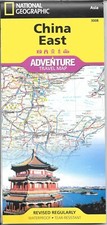
Adventurers seeking a map covering China in totality may prefer National Geographic's China Adventure Map. National Geographic's East China Adventure Map will lead you not only on your exploration of famous cities like Beijing, Shanghai and Guangzhou but also as you travel to hundreds of natural, cultural or historical points of interest, including those away from major tourist hubs.
- Buy It NowMap of China - East, by National Geographic Adventure Maps #3008
Oops! Looks like we're having trouble connecting to our server.
Refresh your browser window to try again.
About this product
Product Identifiers
PublisherNational Geographic Maps
ISBN-101566955939
ISBN-139781566955935
eBay Product ID (ePID)113444498
Product Key Features
Edition2020
Book TitleChina East : Adventure Travel Map
Number of Pages1 Pages
LanguageEnglish
Publication Year2020
TopicMaps & Road Atlases (See Also Reference / Atlases, Gazetteers & Maps), Asia / China
IllustratorYes
GenreTravel
AuthorNational Geographic Staff, National Geographic Maps-Adventure
Book SeriesNational Geographic Adventure Map Ser.
FormatSheet Map, Folded
Dimensions
Item Height0.1 in
Item Weight3.2 Oz
Item Length9.2 in
Item Width4.2 in
Additional Product Features
Intended AudienceTrade
Series Volume Number3008
SynopsisNational Geographic's China, East Adventure Map is designed to meet the unique needs of adventure travelers with its durability and accurate information. This folded map provides global travelers with the perfect combination of detail and perspective, highlighting hundreds of points of interest and the diverse and unique destinations within the country. The map includes the locations of cities and towns with a user-friendly index, plus a clearly marked road network complete with distances and designations for major highways, main roads, and tracks and trails for those seeking to explore more remote regions. The front side of the China East map details the northeast region of the country, from its border with Russia and Mongolia to the north, to the North Korean border to the east, and extending south to the city of Nanjing. The reverse side of the map details China's southeastern region, extending from Xi'an and Zhengzhou south to Hong Kong; west to the country's borders with India and Myanmar (Burma); and east to the Vietnamese border and the shores of the South and East China Seas. Every Adventure Map is printed on durable synthetic paper, making them waterproof, tear-resistant and tough - capable of withstanding the rigors of international travel. Each is two-sided and can be folded to a packable size of 235 x 108 mm; unfolded size is 965 x 660 mm., - Waterproof - Tear-Resistant - Travel Map The most populous country in the world and one of the cradles of civilization, China is a leading destination for global travelers. National Geographic's East China Adventure Map will lead you not only on your exploration of famous cities like Beijing, Shanghai and Guangzhou but also as you travel to hundreds of natural, cultural or historical points of interest, including those away from major tourist hubs. The eastern half of the country includes the most heavily populated areas, including all of the megacities. Also covered are the Yellow, East China and South China Seas; the islands of Taiwan, Hong Kong and Macao; and the entire Korean Peninsula. Find your destination with the user-friendly index of cities and towns or look for pinpointed areas of interest like national parks and preserves, beaches, ski areas, caves, archeological sites and Buddhist Temples. Among the World Heritage Sites in the area are the Great Wall, Terracotta Warriors, Forbidden City, Mount Tai and South China Karst. Navigate the country using the mapped road network, showing motorways, major and secondary roads complete with distance markers. Get to hidden gems in rural areas with the help of smaller roads, railroads and ferries. The map is the perfect complement to National Geographic's China Traveler's Guide or any other guidebook to the area. Adventurers seeking a map covering China in totality may prefer National Geographic's China Adventure Map. Every Adventure Map is printed on durable synthetic paper, making them waterproof, tear-resistant and tough -- capable of withstanding the rigors of international travel. Map Scale = 1:2,950,000 Sheet Size = 25.5" x 37.75" Folded Size = 4.25" x 9.25"
All listings for this product

![China, East: Travel Maps International Adventure Map [Blank book]](https://i.ebayimg.com/images/g/j28AAeSwyRxojYqx/s-l225.jpg)


Be the first to write a review