Picture 1 of 2


Gallery
Picture 1 of 2
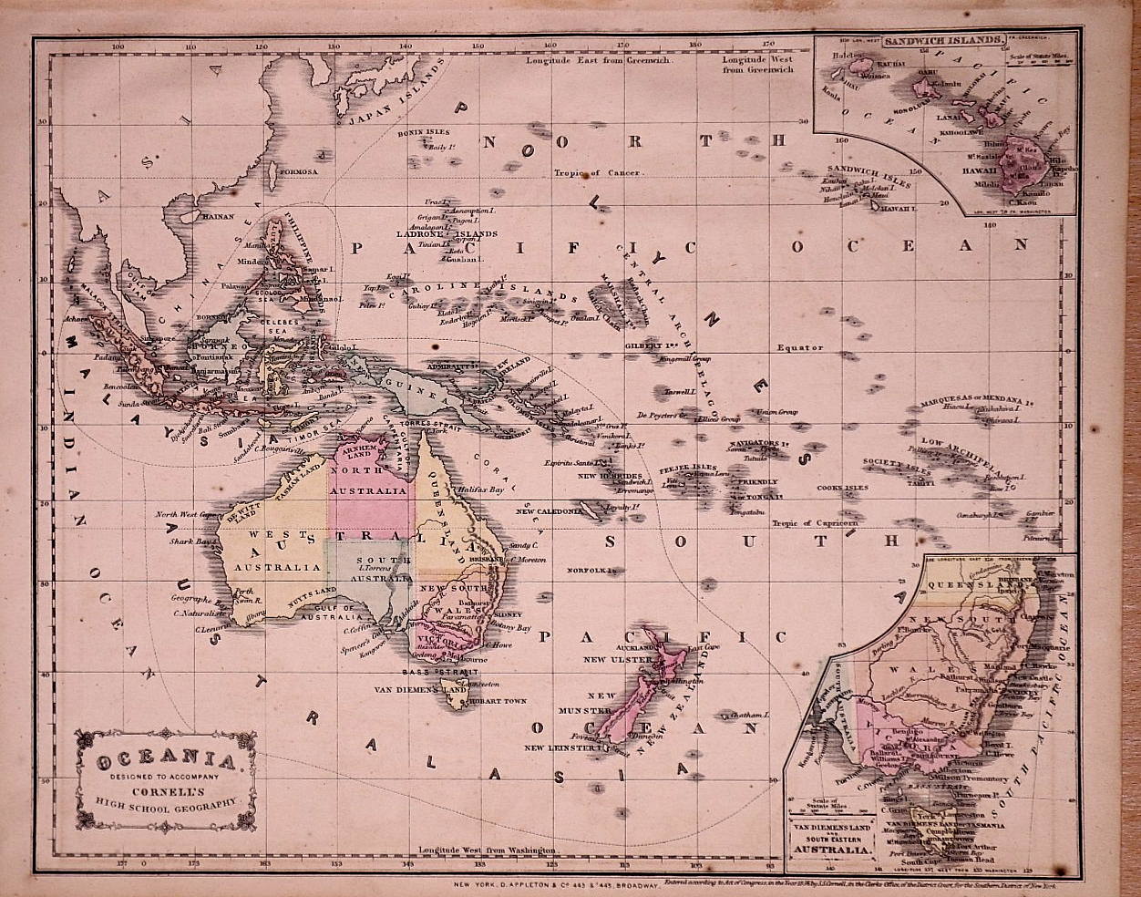

Antique 1864 Map South Pacific - Australia, New Zealand, Sandwich Islands 11x13

US $24.00or Best Offer
Condition:
“Quick 'n Free S&H!! This map is not *new* or in *new* condition: some stains. See photo for the ”... Read moreabout condition
- Buy It NowAntique 1864 Map South Pacific - Australia, New Zealand, Sandwich Islands 11x13
Oops! Looks like we're having trouble connecting to our server.
Refresh your browser window to try again.
Shipping, returns, and payments
Shipping:
Free FedEx Ground Economy®.
Located in: New Braunfels, Texas, United States
Delivery:
Estimated between Fri, Jun 5 and Tue, Jun 9 to 91768
Returns:
30 days returns. Seller pays for return shipping.
Payments:
Special financing available. Learn more- for PayPal Credit, opens in a new window or tab
Shop with confidence
About this item
Seller assumes all responsibility for this listing.
eBay item number:406893735752
Item specifics
- Seller Notes
- Title page
- The book cover and title page are not included in the sale.
- Year
- 1864
- S&H
- Free S&H USA - Calculated S&H Worldwide
- Size
- Approx. 11" x 13".
- Color
- Hand tinted - original coloring
- Original/Reproduction
- Antique Original
- Cartographer/Publisher
- S. S. Cornell / A. Appleton Pub.
- Age
- Over 160 years old.
- Date
- Dated in fine print at base of page.
Item description from the seller

Seller feedback (11,955)
- l***a (823)- Feedback left by buyer.Past monthVerified purchaseNice map, it’s as advertised, and was packaged very well. Your communication could be better, I messaged you more than once and never got any assurance or explanation of how the item was shipped. Tracking said it was delivered days ago and arrived 3 days after they posted that it was actually delivered. An explanation of how it was sent would have helped
- r***8 (27)- Feedback left by buyer.Past 6 monthsVerified purchaseWell packaged for shipping. . Package was lost at one point, not due to seller. It was tracked and located.. We were able to communicate and wait it out. I have ordered another of this seller's maps. I do have a question as too the date of the map. According to my research, the map shows a house (I researched) not built until 1913/14. Sold to Dr. Burkhalter by owner/builder not long after built. I'm glad to have this map for further research, however, I was so hoping for a 1910 version.
- e***i (143)- Feedback left by buyer.Past 6 monthsVerified purchaseOUTSTANDING!!! (Received two maps so this review is replicate on the other map feedback as well) MapHatter is the consummate professional seller whose pictures & descriptions of items sold to me were EXACTLY as described & appeared in the photos. I don't think I've received a better shipping and packaging than I received for these 2 maps. MapHatter sets the standard for how others "should" ship items so that USPS/FEDEX/UPS can't otherwise damage them. Will ALWAYS look to do business here!*Antique 1881 Map ~ Territory of Wyoming ~ (11x15)-#35 (#406495944891)
More to explore :
- New Zealand Antique Australia/Oceania Maps & Atlases,
- New Zealand Antique Australia/Oceania Atlas Maps,
- Auckland New Zealand Antique Australia/Oceania Maps & Atlases,
- New Zealand Antique Original Antique Australia/Oceania Atlas Maps,
- New Zealand Antique Original Antique Australia/Oceania Maps & Atlases,
- New Zealand Lithography Antique Australia/Oceania Maps & Atlases,
- Cook Islands Antique Australia/Oceania Maps & Atlases,
- New Zealand 1900-1909 Date Range Antique Australia/Oceania Maps & Atlases,
- New Zealand 1800-1899 Date Range Antique Australia/Oceania Maps & Atlases,
- Antique South American Maps & Atlases Falkland Islands
Seller feedback (11,955)
- l***a (823)- Feedback left by buyer.Past monthVerified purchaseNice map, it’s as advertised, and was packaged very well. Your communication could be better, I messaged you more than once and never got any assurance or explanation of how the item was shipped. Tracking said it was delivered days ago and arrived 3 days after they posted that it was actually delivered. An explanation of how it was sent would have helped
- r***8 (27)- Feedback left by buyer.Past 6 monthsVerified purchaseWell packaged for shipping. . Package was lost at one point, not due to seller. It was tracked and located.. We were able to communicate and wait it out. I have ordered another of this seller's maps. I do have a question as too the date of the map. According to my research, the map shows a house (I researched) not built until 1913/14. Sold to Dr. Burkhalter by owner/builder not long after built. I'm glad to have this map for further research, however, I was so hoping for a 1910 version.
- e***i (143)- Feedback left by buyer.Past 6 monthsVerified purchaseOUTSTANDING!!! (Received two maps so this review is replicate on the other map feedback as well) MapHatter is the consummate professional seller whose pictures & descriptions of items sold to me were EXACTLY as described & appeared in the photos. I don't think I've received a better shipping and packaging than I received for these 2 maps. MapHatter sets the standard for how others "should" ship items so that USPS/FEDEX/UPS can't otherwise damage them. Will ALWAYS look to do business here!*Antique 1881 Map ~ Territory of Wyoming ~ (11x15)-#35 (#406495944891)