
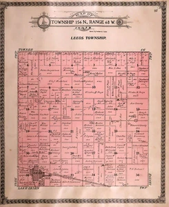
Old Vintage 1910 Plat Map ~ LEEDS Twp., BENSON Co., NORTH DAKOTA ~ Free S&H
US $24.00US $24.00
Wed, Jul 09, 02:59 PMWed, Jul 09, 02:59 PM
Picture 1 of 3

Gallery
Picture 1 of 3


Have one to sell?
Old Vintage 1910 Plat Map ~ LEEDS Twp., BENSON Co., NORTH DAKOTA ~ Free S&H
US $24.00
Ends in
Condition:
“Quick N Free S&H ~ Reasonable offers considered. Browse through 1,000s of Rare, Authentic, Antique & ”... Read moreabout condition
Ended: Jul 09, 2025 14:59:00 PDT
Oops! Looks like we're having trouble connecting to our server.
Refresh your browser window to try again.
Shipping:
Free USPS Ground Advantage®.
Located in: Schertz, Texas, United States
Delivery:
Estimated between Thu, Sep 11 and Wed, Sep 17 to 94104
Returns:
30 days returns. Buyer pays for return shipping. If you use an eBay shipping label, it will be deducted from your refund amount.
Payments:
Special financing available. See terms and apply now- for PayPal Credit, opens in a new window or tab
Earn up to 5x points when you use your eBay Mastercard®. Learn moreabout earning points with eBay Mastercard
Shop with confidence
Seller assumes all responsibility for this listing.
eBay item number:406020837050
Item specifics
- Seller Notes
- Frame
- Suitable for framing.
- US State
- North Dakota
- Color
- All colors are original.
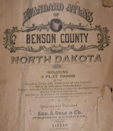
- Cartographer/Publisher
- Geo. A. Ogle
- California Prop 65 Warning
- None
- Date Range
- 1910
- Type
- Plat & County Map
- Format
- Plat Atlas Map
- Year
- 1910
- Ref#
- BENSON-ND1910/022523
- Original/Reproduction
- Antique Original
- Country/Region
- United States of America
- Original
- This map page was printed in 1910.
Item description from the seller
Seller Feedback
No feedback yet
More to explore :
- North Dakota Antique North American Maps & Atlases 1910-1919 Date Range,
- North Dakota 1910-1919 Date Range Antique North America County Maps,
- North Dakota Vintage Original Antique North America Folding Maps,
- North Dakota Vintage Original Antique North America Maps & Atlases,
- North Dakota Antique Original Antique North American Maps & Atlases 1910-1919 Date Range,
- North Dakota Antique North America County Maps,
- Rand McNally & Co. 1910-1919 Date Range Antique North America Atlas Maps,
- Lithography North Dakota Antique North America Maps & Atlases,
- Vintage Reproduction Antique North American Maps & Atlases 1910-1919 Date Range,
- 1910-1919 Date Range Railroad Map Antique North America Folding Maps