Picture 1 of 1
Gallery
Picture 1 of 1

Have one to sell?
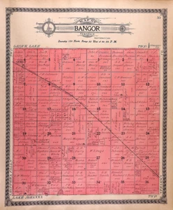
1910 Plat Map ~ BANGOR Twp., POPE Co., MINNESOTA (15x17)-#18

US $28.00
or Best Offer
Condition:
“This map was printed in 1910, is not *new* or *new* condition. It was removed from an Antique Pope ”... Read moreabout condition
- Buy It Now1910 Plat Map ~ BANGOR Twp., POPE Co., MINNESOTA (15x17)-#18
Oops! Looks like we're having trouble connecting to our server.
Refresh your browser window to try again.
Shipping:
Free FedEx Ground Economy®.
Located in: New Braunfels, Texas, United States
Delivery:
Estimated between Fri, Nov 7 and Fri, Nov 14 to 94104
Returns:
30 days returns. Buyer pays for return shipping. If you use an eBay shipping label, it will be deducted from your refund amount.
Payments:
Special financing available. See terms and apply now- for PayPal Credit, opens in a new window or tab
Earn up to 5x points when you use your eBay Mastercard®. Learn moreabout earning points with eBay Mastercard
Shop with confidence
Seller assumes all responsibility for this listing.
eBay item number:405829647820
Item specifics
- Seller Notes
- US State
- Minnesota
- Format
- Plat Map
- Year
- 1910
- S&H
- Free S&H USA - Calculated S&H Worldwide
- SIZE
- Approx. 15 x 17 inches.
- Color
- Original coloring
- Original/Reproduction
- Antique Original
- Land Owners
- Great for ancestry, genealogy & family history research
- County
- Pope County
- Original
- This map page was printed in 1910.
- Age
- Over 120 years old.
Item description from the seller

Seller feedback (10,137)
- w***3 (428)- Feedback left by buyer.Past 6 monthsVerified purchaseWhat should have been a speedy delivery via Ground Advantage delayed due to the incompetence of the USPS. Item sent from Texas to Chicago, then to Pennsylvania (!), the back to Chicago, finally delivered on July 22. The seller did everything right: prompt shipping, excellent packaging, item as described and worth the price. The score: Seller 10, USPS 0.1862 Map ~ KENTUCKY - TENNESSEE ~ S. Augustus Mitchell (12x15)-#06 (#357251577107)
- o***d (922)- Feedback left by buyer.Past 6 monthsVerified purchaseItem exactly as described and shipped in a very protective package. It took almost 3 weeks for the shipping but the shipping was included in the price. Very good value and worth waiting for. Thank you!1898 City Map ~ PITTSBURGH & ALLEGHENY, PENNSYLVANIA (14x22)-#149 (#357219486507)
- e***6 (307)- Feedback left by buyer.Past monthVerified purchaseThis vendor is really amazing. Perfectly sent in a nice box and arrived quickly. Also lowered the price as well. Great value! Would shop again with them and was just as described.
More to explore :
- Minnesota 1910-1919 Date Range Antique North America Folding Maps,
- Minnesota 1910-1919 Date Range Antique North America County Maps,
- Antique North American Maps Minnesota 1910-1919 Date Range Atlases,
- Rand McNally & Co. Minnesota Antique North America Maps & Atlases,
- Rand McNally & Co. 1910-1919 Date Range Antique Atlas Maps,
- Rand McNally & Co. 1910-1919 Date Range Antique Railroad Maps,
- Rand McNally & Co. 1910-1919 Date Range Antique North America Atlas Maps,
- Rand McNally & Co. Lithography Antique Maps, Atlases & Globes 1910-1919 Date Range,
- Antique North American Maps & Atlases Minnesota,
- Atlas Map Topographical Map 1910-1919 Date Range Antique Maps, Atlases & Globes
Seller feedback (10,137)
- w***3 (428)- Feedback left by buyer.Past 6 monthsVerified purchaseWhat should have been a speedy delivery via Ground Advantage delayed due to the incompetence of the USPS. Item sent from Texas to Chicago, then to Pennsylvania (!), the back to Chicago, finally delivered on July 22. The seller did everything right: prompt shipping, excellent packaging, item as described and worth the price. The score: Seller 10, USPS 0.1862 Map ~ KENTUCKY - TENNESSEE ~ S. Augustus Mitchell (12x15)-#06 (#357251577107)
- o***d (922)- Feedback left by buyer.Past 6 monthsVerified purchaseItem exactly as described and shipped in a very protective package. It took almost 3 weeks for the shipping but the shipping was included in the price. Very good value and worth waiting for. Thank you!1898 City Map ~ PITTSBURGH & ALLEGHENY, PENNSYLVANIA (14x22)-#149 (#357219486507)
- e***6 (307)- Feedback left by buyer.Past monthVerified purchaseThis vendor is really amazing. Perfectly sent in a nice box and arrived quickly. Also lowered the price as well. Great value! Would shop again with them and was just as described.