
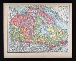
1894 Cram Map Canada Ontario Quebec Hudson Bay British Columbia Alberta Manitoba
US $14.00US $14.00
Wed, Sep 24, 05:28 PMWed, Sep 24, 05:28 PM
Picture 1 of 4


Gallery
Picture 1 of 4


Have one to sell?
1894 Cram Map Canada Ontario Quebec Hudson Bay British Columbia Alberta Manitoba
US $14.00
or Best Offer
Was US $17.50 (20% off)
Condition:
“Very Good to Excellent condition, the image area measures approximately 8 by 10 inches (20x26cm) on ”... Read moreabout condition
Ended: Sep 24, 2025 17:28:06 PDT
Oops! Looks like we're having trouble connecting to our server.
Refresh your browser window to try again.
Shipping:
US $4.99 USPS Ground Advantage®.
Located in: Fairview, Pennsylvania, United States
Delivery:
Estimated between Mon, Nov 10 and Mon, Nov 17 to 94104
Returns:
30 days returns. Seller pays for return shipping.
Payments:
Special financing available. See terms and apply now- for PayPal Credit, opens in a new window or tab
Earn up to 5x points when you use your eBay Mastercard®. Learn moreabout earning points with eBay Mastercard
Shop with confidence
Seller assumes all responsibility for this listing.
eBay item number:405814976121
Item specifics
- Seller Notes
- Publication Year
- 1894
- Date Range
- 1800-1899
- Type
- County Map
- Printing Technique
- Lithography
- Format
- Atlas Map
- Year
- 1894
- Canadian Province
- Alberta, British Columbia, Manitoba, New Brunswick, Northwest Territories, Nova Scotia, Ontario, Prince Edward Island, Quebec, Saskatchewan
- Cartographer/Publisher
- George Cram
- Original/Reproduction
- Antique Original
- City
- Toronto
- Topic
- Maps
- Country/Region
- Canada
Item description from the seller
Seller Feedback
No feedback yet
More to explore :
- Manitoba George Cram Canada Antique North America Maps & Atlases,
- Quebec George Cram Canada Antique North America Maps & Atlases,
- Ontario George Cram Canada Antique North America Maps & Atlases,
- British Columbia George Cram Antique North America Maps & Atlases,
- British Columbia Canada American Antique Maps & Atlases,
- British Columbia Vancouver Canada Antique North America Maps & Atlases,
- Quebec Canada Antique North America Railroad Maps,
- Quebec Canada Antique North America City Maps,
- Ontario Canada Antique North America Topographical Maps,
- Quebec City Canada Antique North America Maps & Atlases