
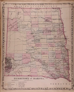
Dated 1879 Map ~ THE DAKOTA TERRITORY by S. Augustus Mitchell (12x15)-#04
US $68.00US $68.00
Fri, Aug 01, 07:46 AMFri, Aug 01, 07:46 AM
Picture 1 of 2

Gallery
Picture 1 of 2


Have one to sell?
Dated 1879 Map ~ THE DAKOTA TERRITORY by S. Augustus Mitchell (12x15)-#04
US $68.00
or Best Offer
Condition:
“This 140-year-old map is not *new* or in *new* condition, it was printed in 1879. See photo for the ”... Read moreabout condition
Oops! Looks like we're having trouble connecting to our server.
Refresh your browser window to try again.
Shipping:
Free USPS Ground Advantage®.
Located in: Schertz, Texas, United States
Delivery:
Estimated between Wed, Nov 5 and Wed, Nov 12 to 94104
Returns:
30 days returns. Seller pays for return shipping.
Payments:
.
Special financing available. See terms and apply now- for PayPal Credit, opens in a new window or tab
Earn up to 5x points when you use your eBay Mastercard®. Learn moreabout earning points with eBay Mastercard
Shop with confidence
Seller assumes all responsibility for this listing.
eBay item number:405716326291
Item specifics
- Seller Notes
- US State
- North Dakota, South Dakota
- Size
- The page is approx. 12x15
- Color
- Original hand tinted colors.
- Cartographer/Publisher
- S. Augustus Mitchell
- Date Range
- 1879
- Ref
- The title page is only for reference purposes. It is not included
- Type
- State Map
- Format
- Atlas Map
- S&H
- Free S&H USA - Calculated S&H Worldwide
- Year
- 1879
- Original/Reproduction
- Antique Original
- Country/Region
- United States of America
- Age
- over 140 years old
Item description from the seller
Seller Feedback
No feedback yet
More to explore :
- Samuel Augustus Mitchell 1800-1899 Date Range Antique Atlas Maps,
- Samuel Augustus Mitchell Antique Atlas Maps,
- Samuel Augustus Mitchell Antique County Maps,
- Samuel Augustus Mitchell 1800-1899 Date Range Antique Maps, Atlases & Globes,
- Samuel Augustus Mitchell 1800-1899 Date Range Antique Europe Maps & Atlases,
- Samuel Augustus Mitchell Woodcut Antique Maps, Atlases & Globes 1800-1899 Date Range,
- Samuel Augustus Mitchell Antique Original Antique County Maps,
- Samuel Augustus Mitchell Woodcut Antique Maps, Atlases & Globes,
- C. Augustus Antique Maps, Atlases & Globes 1800-1899 Date Range,
- Samuel Augustus Mitchell Lithography Antique Original Antique Maps, Atlases & Globes