
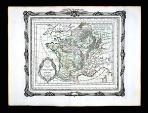
1764 Zannoni Map France 7th Century Arboriques Visogoth Ghildebert Orleans Paris
US $87.50US $87.50
Mon, Oct 20, 08:13 AMMon, Oct 20, 08:13 AM
Picture 1 of 3


Gallery
Picture 1 of 3


Have one to sell?
1764 Zannoni Map France 7th Century Arboriques Visogoth Ghildebert Orleans Paris

US $87.50
Was US $125.00 (30% off)
Condition:
“Very Good to Excellent condition for its age, approximately 10x11 inches (25x28cm) on a 11 1/2 x15" ”... Read moreabout condition
Ended: Oct 20, 2025 08:13:04 PDT
Oops! Looks like we're having trouble connecting to our server.
Refresh your browser window to try again.
Shipping:
US $4.99 USPS Ground Advantage®.
Located in: Fairview, Pennsylvania, United States
Delivery:
Estimated between Fri, Oct 24 and Thu, Oct 30 to 94104
Returns:
30 days returns. Seller pays for return shipping.
Payments:
.
Special financing available. See terms and apply now- for PayPal Credit, opens in a new window or tab
Earn up to 5x points when you use your eBay Mastercard®. Learn moreabout earning points with eBay Mastercard
Shop with confidence
Seller assumes all responsibility for this listing.
eBay item number:405517214945
Item specifics
- Seller Notes
- Cartographer/Publisher
- Rizzi Zannoni
- Printing Technique
- Copper Plate
- Original/Reproduction
- Antique Original
- Format
- Atlas Map
- Type
- Political Map
- Year
- 1764
- Date Range
- 1700-1799
- City
- Paris
- Country/Region
- Belgium, France, Germany, Holland
Item description from the seller

Popular categories from this store
Seller feedback (20,008)
- 1***m (15)- Feedback left by buyer.Past 6 monthsVerified purchaseVendor good to deal with, second or third time I have bought from them. Item as descried and in good condition Safely packed Delivery time good. Recommend vendor1869 Bartholomew Map Queensland Cape York Melville Brisbane Cairns Australia (#405337580929)
- x***u (161)- Feedback left by buyer.Past 6 monthsVerified purchaseMy second order from this seller. As before, the shipping was fast and the map was well packed and protected. Included with the original map was a photocopy of the title page of the book the map came from. Definitely one of my favorite sellers!1836 Gordon Map Syracuse Salina City Plan Mill Pond Salt Company Oswego Canal NY (#365563445498)
- l***4 (139)- Feedback left by buyer.Past yearVerified purchaseVery nice. Received as seller described on their web site. It was well packaged and at a decent cost. Seller was good at communication and is willing to work with the customer.1857 Morse Map North Carolina Cape Hatteras Raleigh Durham Asheville Beaufort NC (#365504242256)
More to explore :
- Paris France Antique Maps,
- Paris France Antique Europe City Maps,
- Paris France Antique Europe Atlas Maps,
- Paris France Antique Europe County Maps,
- Paris France Antique Europe Folding Maps,
- Paris France Antique Europe Railroad Maps,
- Paris France Antique Europe River Maps,
- Paris City Map Antique Europe Atlas Maps,
- France County Map Antique Europe Atlas Maps,
- Paris Antique Europe City Maps
Popular categories from this store
Seller feedback (20,008)
- 1***m (15)- Feedback left by buyer.Past 6 monthsVerified purchaseVendor good to deal with, second or third time I have bought from them. Item as descried and in good condition Safely packed Delivery time good. Recommend vendor1869 Bartholomew Map Queensland Cape York Melville Brisbane Cairns Australia (#405337580929)
- x***u (161)- Feedback left by buyer.Past 6 monthsVerified purchaseMy second order from this seller. As before, the shipping was fast and the map was well packed and protected. Included with the original map was a photocopy of the title page of the book the map came from. Definitely one of my favorite sellers!1836 Gordon Map Syracuse Salina City Plan Mill Pond Salt Company Oswego Canal NY (#365563445498)
- l***4 (139)- Feedback left by buyer.Past yearVerified purchaseVery nice. Received as seller described on their web site. It was well packaged and at a decent cost. Seller was good at communication and is willing to work with the customer.1857 Morse Map North Carolina Cape Hatteras Raleigh Durham Asheville Beaufort NC (#365504242256)