
Picture 1 of 2

Gallery
Picture 1 of 2


Have one to sell?
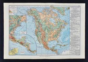
1885 Drioux Map - North America Physical - United States Canada Mexico Mountains

US $18.00
or Best Offer
Was US $22.50 (20% off)
Condition:
“Good condition, 11 x 16 1/2 inches on a 13 by 19" page (33x48cm), see the pics and description ”... Read moreabout condition
Sale ends in: 6d 5h
- Buy It Now1885 Drioux Map - North America Physical - United States Canada Mexico Mountains
Oops! Looks like we're having trouble connecting to our server.
Refresh your browser window to try again.
Shipping:
US $4.99 USPS Ground Advantage®.
Located in: Fairview, Pennsylvania, United States
Delivery:
Estimated between Sat, Aug 23 and Thu, Aug 28 to 94104
Returns:
30 days returns. Seller pays for return shipping.
Payments:
Special financing available. See terms and apply now- for PayPal Credit, opens in a new window or tab
Earn up to 5x points when you use your eBay Mastercard®. Learn moreabout earning points with eBay Mastercard
Shop with confidence
Seller assumes all responsibility for this listing.
eBay item number:405424097697
Item specifics
- Seller Notes
- Country/Region
- United States of America
- Year
- 1885
- Topic
- Maps
- Publication Year
- 1885
- Original/Reproduction
- Antique Original
- Date Range
- 1800-1899
- US State
- AL, FL, GA, MS, NC, SC, AR, IA, KS, LA, MO, NE, AZ, CA, CO, NM, NV, UT, CT, MA, ME, NH, RI, VT, DC, DE, MD, NJ, NY, PA, ID, OR, WA, IL, IN, MI, OH, WI, MN, MT, ND, SD, WY, OK, TX, VA, WV, KY, TN
- Type
- Physical Map
- Format
- Atlas Map
- City
- Washington
- Canadian Province
- Alberta, British Columbia, Manitoba, New Brunswick, Newfoundland & Labrador, Nova Scotia, Ontario, Prince Edward Island, Quebec, Saskatchewan, Yukon
- Cartographer/Publisher
- Drioux
Item description from the seller

Popular categories from this store
Seller feedback (19,902)
- l***4 (129)- Feedback left by buyer.Past 6 monthsVerified purchaseVery nice. Received as seller described on their web site. It was well packaged and at a decent cost. Seller was good at communication and is willing to work with the customer.1857 Morse Map North Carolina Cape Hatteras Raleigh Durham Asheville Beaufort NC (#365504242256)
- u***g (42)- Feedback left by buyer.Past 6 monthsVerified purchaseGreat seller! Packaged safely and shipped quickly. Great communicator and very knowledgeable. Everything showed up exactly as decribed. Incredible value. 12/10 recommendWest Point WWII Map Operation in Italy Allied Advances from Jan 1944 to Jan 1945 (#365096664387)
- 1***m (14)- Feedback left by buyer.Past monthVerified purchaseVendor good to deal with, second or third time I have bought from them. Item as descried and in good condition Safely packed Delivery time good. Recommend vendor
More to explore :
- United States of America Antique North America Physical Maps,
- United States of America Physical Map Antique North America Atlas Maps,
- Canada Antique North America Physical Maps,
- George Cram United States of America Antique North America Physical Maps,
- Canada Physical Map Antique North America Atlas Maps,
- United States of America New Mexico Antique North America Topographical Maps,
- United States of America 1910-1919 Date Range Antique North America Physical Maps,
- United States of America Antique North America School Maps,
- United States of America Antique North America County Maps,
- Canada 1930-1939 Date Range Antique North America Physical Maps
Popular categories from this store
Seller feedback (19,902)
- l***4 (129)- Feedback left by buyer.Past 6 monthsVerified purchaseVery nice. Received as seller described on their web site. It was well packaged and at a decent cost. Seller was good at communication and is willing to work with the customer.1857 Morse Map North Carolina Cape Hatteras Raleigh Durham Asheville Beaufort NC (#365504242256)
- u***g (42)- Feedback left by buyer.Past 6 monthsVerified purchaseGreat seller! Packaged safely and shipped quickly. Great communicator and very knowledgeable. Everything showed up exactly as decribed. Incredible value. 12/10 recommendWest Point WWII Map Operation in Italy Allied Advances from Jan 1944 to Jan 1945 (#365096664387)
- 1***m (14)- Feedback left by buyer.Past monthVerified purchaseVendor good to deal with, second or third time I have bought from them. Item as descried and in good condition Safely packed Delivery time good. Recommend vendor