
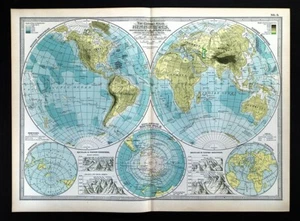
1897 Century Physical World Map South Pole Mountains Asia Europe America Africa
US $31.99US $31.99
Sun, Oct 05, 06:21 PMSun, Oct 05, 06:21 PM
Picture 1 of 4


Gallery
Picture 1 of 4


Have one to sell?
1897 Century Physical World Map South Pole Mountains Asia Europe America Africa
c574778
(16430)
US $31.99
or Best Offer
Was US $39.99 (20% off)
Condition:
“Very Good to Excellent condition, on a 12 by 16 1/2" page (30x42cm), see the pics and description ”... Read moreabout condition
Ended: Oct 05, 2025 18:21:41 PDT
Oops! Looks like we're having trouble connecting to our server.
Refresh your browser window to try again.
Shipping:
US $4.99 USPS Ground Advantage®.
Located in: Fairview, Pennsylvania, United States
Delivery:
Estimated between Mon, Nov 24 and Fri, Nov 28 to 94104
Returns:
30 days returns. Seller pays for return shipping.
Payments:
Special financing available. See terms and apply now- for PayPal Credit, opens in a new window or tab
Earn up to 5x points when you use your eBay Mastercard®. Learn moreabout earning points with eBay Mastercard
Shop with confidence
About this item
Seller assumes all responsibility for this listing.
eBay item number:405403362878
Item specifics
- Seller Notes
- Engraver
- Matthews-Northrup Co.
- Date Range
- 1800-1899
- Type
- Physical Map
- Format
- Atlas Map
- Printing Technique
- Lithography
- Year
- 1897
- Map View
- World
- Original/Reproduction
- Antique Original
- Cartographer/Publisher
- The Century Co.
Item description from the seller
Seller Feedback
No feedback yet
More to explore :
- Antique South America Physical Maps,
- Physical Map Antique South America Atlas Maps,
- Lithography Antique South America Physical Maps,
- Antique Africa Physical Maps,
- Antique Europe Physical Maps,
- Antique Original Antique South America Physical Maps,
- Lithography Antique Europe Physical Maps,
- Germany Physical Map Antique Europe Sheet Maps,
- Lithography Physical Map Antique Asia Atlas Maps,
- 1800-1899 Date Range Antique South America Physical Maps