Picture 1 of 7


Picture 1 of 7


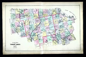
1900 Stuart Maine Map Timber Lands Aroostook Penobscot Hancock County Lincoln ME

US $31.99
or Best Offer
Was US $39.99 (20% off)
Condition:
“There are three Timber Land Maps No. 2, 3 and 4 on one large sheet with one large map No. 3 and two ”... Read moreabout condition
Ended: Jul 31, 2024 18:47:46 PDT
Shipping:
US $4.99 USPS Ground Advantage®.
Located in: Fairview, Pennsylvania, United States
Delivery:
Estimated between Fri, Sep 27 and Mon, Sep 30 to 43230
Returns:
30 days returns. Seller pays for return shipping.
Payments:
Special financing available. See terms and apply now- for PayPal Credit, opens in a new window or tab
Earn up to 5x points when you use your eBay Mastercard®. Learn moreabout earning points with eBay Mastercard
Shop with confidence
Seller assumes all responsibility for this listing.
eBay item number:404652285106
Item specifics
- Seller Notes
- Date Range
- 1900-1909
- Type
- County Map
- US State
- CT, MA, ME, NH, RI, VT, Maine
- Format
- Atlas Map
- Canadian Province
- Quebec
- Year
- 1900
- Original/Reproduction
- Antique Original
- Cartographer/Publisher
- Stuart
- Country/Region
- United States of America
Item description from the seller

More to explore :
- Maine 1900-1909 Date Range Antique North America County Maps,
- Maine Antique North America County Maps,
- Washington Maine Antique North America County Maps,
- Maine County Map Antique North America Atlas,
- Maine Contemporary Antique North America County Maps,
- Antique County Maps,
- County Map Antique Folding Maps,
- County Map Antique Wall Maps,
- England 1900-1909 Date Range Antique Europe County Maps,
- Antique Europe County Maps