Picture 1 of 2

Picture 1 of 2


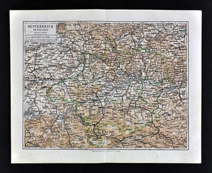
1900 Meyers Map Austria Enns Linz Hallein Wels Steyr Passau Ischl Danube River

US $12.00
or Best Offer
Was US $15.00 (20% off)
Condition:
“Good to Very Good, on a 9 1/2 by 12 inch page (24x30cm), see the pics and description for more ”... Read moreabout condition
Ended: Jul 18, 2024 10:23:10 PDT
Shipping:
US $4.99 USPS Ground Advantage®.
Located in: Fairview, Pennsylvania, United States
Delivery:
Estimated between Thu, Sep 26 and Sat, Sep 28 to 43230
Returns:
30 days returns. Seller pays for return shipping.
Payments:
Special financing available. See terms and apply now- for PayPal Credit, opens in a new window or tab
Earn up to 5x points when you use your eBay Mastercard®. Learn moreabout earning points with eBay Mastercard
Shop with confidence
Seller assumes all responsibility for this listing.
eBay item number:404644443894
Item specifics
- Seller Notes
- Original/Reproduction
- Antique Original
- Format
- Atlas Map
- Type
- City Map
- Year
- 1900
- City
- Vienna
- Date Range
- 1900-1909
- Country/Region
- Austria
Item description from the seller

More to explore :
- Austria 1900-1909 Date Range Antique Europe Atlas Maps,
- Austria 1900-1909 Date Range Antique Europe City Maps,
- 1900-1909 Date Range Antique River Maps,
- Antique European Maps & Atlases 1900-1909 Date Range Austria,
- Contemporary 1900-1909 Date Range Antique River Maps,
- Vienna Antique European Maps & Atlases 1900-1909 Date Range Austria,
- Austria Antique Europe City Maps,
- Austria Antique Europe Political Maps,
- Austria Vienna Antique Europe City Maps,
- River Map Antique Folding Maps