Picture 1 of 3


Gallery
Picture 1 of 3


Have one to sell?
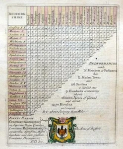
BEDFORD DISTANCE CHART MORDEN / VAN LANGEREN c1720 GENUINE ANTIQUE ENGRAVING

GBP 34.99
ApproximatelyUS $46.79
Condition:
- Buy It NowBEDFORD DISTANCE CHART MORDEN / VAN LANGEREN c1720 GENUINE ANTIQUE ENGRAVING
Oops! Looks like we're having trouble connecting to our server.
Refresh your browser window to try again.
Shipping:
GBP 8.00 (approx US $10.70) Royal Mail International Tracked.
Located in: Poole, United Kingdom
Delivery:
Estimated between Mon, Oct 27 and Fri, Nov 7 to 94104
Returns:
Seller does not accept returns.
Payments:
Earn up to 5x points when you use your eBay Mastercard®. Learn moreabout earning points with eBay Mastercard
Shop with confidence
Seller assumes all responsibility for this listing.
eBay item number:393087870843
Item specifics
- Type
- County Distance Chart
- Date Range
- 1700-1799
- Year
- 1731
- Country/Region
- England, United Kingdom
- County
- Bedfordshire
- Cartographer/Publisher
- Robert Morden / Van Langeren
- Era
- 1700s
- Printing Technique
- Copper Plate
- Original/Reproduction
- Antique Original
- Antique
- Yes
Item description from the seller

Popular categories from this store
Seller feedback (1,348)
- o***h (261)- Feedback left by buyer.Past 6 monthsVerified purchaseExcellent communications. Delivery on time and at reasonable cost. Great packaging. Item exactly as described. Will definitely purchase from seller again.
- n***t (637)- Feedback left by buyer.Past 6 monthsVerified purchasePostage was included in the price I paid. The item was well packaged and arrived quickly. There were two of these maps available but I opted to buy this as it was in much better condition. I paid a bit more for this one but it was worth. Communication with the seller was very good.YORKSHIRE WEST RIDING BY HERMAN MOLL c1724 ORIGINAL ANTIQUE ENGRAVED MAP (#396507130493)
- l***s (3533)- Feedback left by buyer.Past 6 monthsVerified purchaseClassic OS map in very good condition. Beautifully wrapped and packed in a document box, complete with signed certificate of authenticity. Quick delivery. Excellent service from very knowledgeable and professional seller.WORCESTERSHIRE WARWICKSHIRE c1831 GENUINE 1st EDITION ORDNANCE SURVEY MAP (#396328611974)
More to explore :
- Antique Maritime Navigational Charts,
- Engraved Antique Maritime Compasses,
- Antique Reproduction Antique Maritime Navigational Charts,
- Antique Original Antique Maritime Navigational Charts,
- Old Maryland Engraved Silver Antiques,
- Antique Old Maryland Engraved Sterling Silver Flatware,
- Kirk Old Maryland Engraved Silver Antiques,
- Kirk Antique US Sterling Silver Old Maryland Engraved,
- Old Maryland Engraved US Sterling Silver Antiques,
- British Merchant Navy Antique Maritime Navigational Charts
Popular categories from this store
Seller feedback (1,348)
- o***h (261)- Feedback left by buyer.Past 6 monthsVerified purchaseExcellent communications. Delivery on time and at reasonable cost. Great packaging. Item exactly as described. Will definitely purchase from seller again.
- n***t (637)- Feedback left by buyer.Past 6 monthsVerified purchasePostage was included in the price I paid. The item was well packaged and arrived quickly. There were two of these maps available but I opted to buy this as it was in much better condition. I paid a bit more for this one but it was worth. Communication with the seller was very good.YORKSHIRE WEST RIDING BY HERMAN MOLL c1724 ORIGINAL ANTIQUE ENGRAVED MAP (#396507130493)
- l***s (3533)- Feedback left by buyer.Past 6 monthsVerified purchaseClassic OS map in very good condition. Beautifully wrapped and packed in a document box, complete with signed certificate of authenticity. Quick delivery. Excellent service from very knowledgeable and professional seller.WORCESTERSHIRE WARWICKSHIRE c1831 GENUINE 1st EDITION ORDNANCE SURVEY MAP (#396328611974)