Picture 1 of 3


Gallery
Picture 1 of 3


Have one to sell?
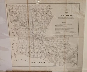
1854 Antique Map: Louisiana Land Districts - Rare Historical Chart

US $60.00
or Best Offer
or 4 interest-free payments of $15.00 available with
Condition:
- Buy It Now1854 Antique Map: Louisiana Land Districts - Rare Historical Chart
Oops! Looks like we're having trouble connecting to our server.
Refresh your browser window to try again.
Shipping:
US $13.30 USPS Ground Advantage®.
Located in: Tillamook, Oregon, United States
Delivery:
Estimated between Wed, Nov 26 and Wed, Dec 3 to 94104
Returns:
Seller does not accept returns.
Payments:
.
Special financing available. See terms and apply now- for PayPal Credit, opens in a new window or tab
Earn up to 5x points when you use your eBay Mastercard®. Learn moreabout earning points with eBay Mastercard
Shop with confidence
About this item
Seller assumes all responsibility for this listing.
eBay item number:387334998015
Item specifics
- US State
- Louisiana
- Year
- 1854
- Date Range
- 1800-1899
- Type
- Topographical Map
- Format
- Folding Map
- Printing Technique
- Copper Plate
- Original/Reproduction
- Antique Original
- Country/Region
- United States of America
Item description from the seller

Seller feedback (27)
- i***i (95)- Feedback left by buyer.Past 6 monthsVerified purchaseExcellent seller. Quick and well packaged. Item exactly as shown. Very reasonable on the price! Will use again!!Antique 1878 Map: Allegheny Arsenal, PA, 9x12, Historical Military Map (#387397542893)
- -***r (661)- Feedback left by buyer.Past yearVerified purchaseItem as described- seller is one that will listen, respond and work with you. A++++~ thanks ! I’ll be back !Antique 1866 map Sketch C. Burnside Expedition Route to Newbern 11x8 Civil War (#388240161234)
- e***e (460)- Feedback left by buyer.Past 6 monthsVerified purchaseItem as promised. Thank you very much.Antique 1881 Map of Missouri River at Glasgow, MO - Corps of Engineers 14x9 (#387742166250)
More to explore :
- Louisiana Topographical Map Antique North America Folding Maps,
- Louisiana Antique North America Railroad Maps,
- Louisiana Antique North America Atlas Maps,
- Antique North American Maps & Atlases Louisiana,
- Louisiana Antique North America Wall Maps,
- Louisiana Antique North America County Maps,
- Louisiana Antique Original Antique North America Folding Maps,
- District of Columbia Antique North America City Maps,
- Louisiana Contemporary Antique North America Atlas Maps,
- District of Columbia Antique Original Antique North America Maps & Atlases
Seller feedback (27)
- i***i (95)- Feedback left by buyer.Past 6 monthsVerified purchaseExcellent seller. Quick and well packaged. Item exactly as shown. Very reasonable on the price! Will use again!!Antique 1878 Map: Allegheny Arsenal, PA, 9x12, Historical Military Map (#387397542893)
- -***r (661)- Feedback left by buyer.Past yearVerified purchaseItem as described- seller is one that will listen, respond and work with you. A++++~ thanks ! I’ll be back !Antique 1866 map Sketch C. Burnside Expedition Route to Newbern 11x8 Civil War (#388240161234)
- e***e (460)- Feedback left by buyer.Past 6 monthsVerified purchaseItem as promised. Thank you very much.Antique 1881 Map of Missouri River at Glasgow, MO - Corps of Engineers 14x9 (#387742166250)