
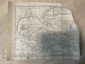
1745 Chart Of Ye West-Indies Islands Americas Map Pirates Herman Moll
US $200.00US $200.00
Tue, Aug 05, 02:19 PMTue, Aug 05, 02:19 PM
Picture 1 of 7


Gallery
Picture 1 of 7


Have one to sell?
1745 Chart Of Ye West-Indies Islands Americas Map Pirates Herman Moll
US $200.00
or Best Offer
Condition:
Oops! Looks like we're having trouble connecting to our server.
Refresh your browser window to try again.
Shipping:
US $20.10 USPS Ground Advantage®.
Located in: Coram, New York, United States
Delivery:
Estimated between Mon, Oct 27 and Mon, Nov 3 to 94104
Returns:
Seller does not accept returns.
Payments:
.
Earn up to 5x points when you use your eBay Mastercard®. Learn moreabout earning points with eBay Mastercard
Shop with confidence
Seller assumes all responsibility for this listing.
eBay item number:376256397860
Item specifics
- Date Range
- 1700-1799
- Type
- Political Map
- US State
- Florida, Georgia, North Carolina, South Carolina
- Format
- Sheet Map
- Printing Technique
- Copper Plate
- Year
- 1745
- Original/Reproduction
- Antique Original
- Cartographer/Publisher
- Hermann Moll
Item description from the seller
Seller Feedback
No feedback yet
More to explore :
- Herman Moll Antique Sheet Maps,
- Herman Moll Antique Asia Sheet Maps,
- Antique European Maps & Atlases Herman Moll,
- Antique Asian Maps & Atlases Herman Moll,
- Herman Moll Antique Maps, Atlases & Globes,
- Antique Asian Herman Moll Lithography Maps & Atlases,
- Herman Moll Antique Maps, Atlases & Globes 1700-1799 Date Range,
- West Virginia Antique North America Maps & Atlases,
- Rhode Island Antique North America Nautical Maps,
- West Virginia Antique North America Topographical Maps