
Picture 1 of 3


Gallery
Picture 1 of 3


Have one to sell?
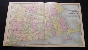
1890 Map MASSACHUSETTS, CONNECTICUT, RHODE ISLAND, b/w BOSTON, b/w NH & VT
US $22.49
or Best Offer
Was US $24.99 (10% off)
Condition:
“used ~ see description for condition”
- Buy It Now1890 Map MASSACHUSETTS, CONNECTICUT, RHODE ISLAND, b/w BOSTON, b/w NH & VT
Oops! Looks like we're having trouble connecting to our server.
Refresh your browser window to try again.
Shipping:
Free USPS Ground Advantage®.
Located in: Monroeville, Pennsylvania, United States
Delivery:
Estimated between Tue, Oct 28 and Mon, Nov 3 to 94104
Returns:
30 days returns. Buyer pays for return shipping. If you use an eBay shipping label, it will be deducted from your refund amount.
Payments:
Special financing available. See terms and apply now- for PayPal Credit, opens in a new window or tab
Earn up to 5x points when you use your eBay Mastercard®. Learn moreabout earning points with eBay Mastercard
Shop with confidence
Seller assumes all responsibility for this listing.
eBay item number:375120998277
Item specifics
- Seller Notes
- “used ~ see description for condition”
- Date Range
- 1800-1899
- Format
- Atlas Map
- US State
- CT, MA, ME, NH, RI, VT, Connecticut, Massachusetts, New Hampshire, Rhode Island, Vermont
- Year
- 1890
- Original/Reproduction
- Antique Original
- City
- Boston
- Country/Region
- United States of America
Item description from the seller
Seller feedback (25,633)
- n***s (8412)- Feedback left by buyer.Past 6 monthsVerified purchaseI have bought many things from this seller and this will serve to be the feedback for all. I am very pleased. All are as described, or better. The packaging is secure and professional. Shipping is fast and I feel that everything that I purchased has been priced fairly. When communication was needed, it was prompt and courteous. You may buy from this store with complete confidence.
- e***k (2470)- Feedback left by buyer.Past 6 monthsVerified purchaseItem photographed for the listing was the one received. The real article is beautiful, in better shape and of finer visual quality than could be conveyed in a picture. Skillful packing by the seller assured that it arrived in pristine condition. The mailer was rigid and protected the print. Great deal on this gorgeous leaf.
- 0***2 (245)- Feedback left by buyer.Past 6 monthsVerified purchaseThrough no fault of seller this item went AWOL in USPS. However, from the very beginning, customer service was A+, communication was as well and although a refund had to be issued, this seller went out of his way to ensure a successful transaction--USPS just got in the way. Would recommend this seller.1883 Map / OUTLINE MAP OF TOWNSHIPS IN MEIGS COUNTY, OHIO / 10.5x14.5 inches (#335116478030)
More to explore :
- Boston Rhode Island Antique North America Maps & Atlases,
- Boston Rhode Island Antique Original Antique North American Maps & Atlases,
- Boston CT, MA, ME, NH, RI, VT Antique North American Maps & Atlases,
- Boston Connecticut Antique North American Maps & Atlases,
- Boston Massachusetts Antique North America Folding Maps,
- Rhode Island County Map Antique North America Atlas Maps,
- Rhode Island Antique North America Railroad Maps,
- Providence Rhode Island Antique North America City Maps,
- CT, MA, ME, NH, RI, VT County Map Antique North America Atlas Maps,
- CT, MA, ME, NH, RI, VT Topographical Map Antique North America Sheet Maps