
Picture 1 of 1
Gallery
Picture 1 of 1
Have one to sell?
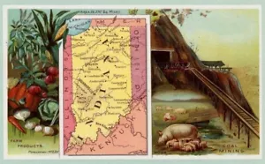
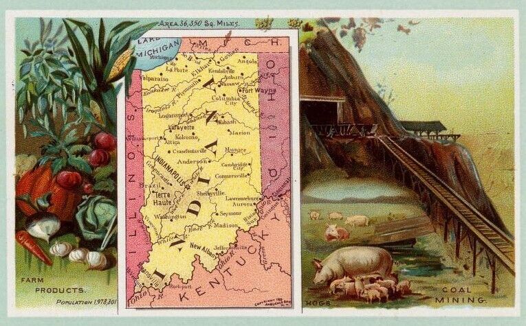
1889 Arbuckle Map of INDIANA
![Pacific Shore [Collectible] Maps](https://i.ebayimg.com/images/g/ti0AAOSwdIZdwbZo/s-l64.jpg)
US $9.25
$8.33 with coupon code
Condition:
“VG to VG+”
- Buy It Now1889 Arbuckle Map of INDIANA
Oops! Looks like we're having trouble connecting to our server.
Refresh your browser window to try again.
Shipping:
US $4.65 USPS Ground Advantage®.
Located in: San Diego, California, United States
Delivery:
Estimated between Tue, Oct 21 and Mon, Oct 27 to 94104
Returns:
14 days returns. Buyer pays for return shipping. If you use an eBay shipping label, it will be deducted from your refund amount.
Payments:
Special financing available. See terms and apply now- for PayPal Credit, opens in a new window or tab
Earn up to 5x points when you use your eBay Mastercard®. Learn moreabout earning points with eBay Mastercard
Shop with confidence
Seller assumes all responsibility for this listing.
eBay item number:374714617716
Item specifics
- Seller Notes
- “VG to VG+”
- Date Range
- 1800-1899
- Printing Technique
- Lithography
- Format
- Sheet Map
- US State
- IL, IN, MI, OH, WI, Utah
- Year
- 1889
- Cartographer/Publisher
- Arbuckle Co.
- Original/Reproduction
- Antique Original
- City
- INdianapolis
Item description from the seller
![Pacific Shore [Collectible] Maps](https://i.ebayimg.com/images/g/ti0AAOSwdIZdwbZo/s-l140.jpg)
Popular categories from this store
Seller feedback (3,125)
- h***m (1131)- Feedback left by buyer.Past 6 monthsVerified purchaseFast ship, nicely packaged, nice map, great seller!!!! AAAAA
- u***e (75)- Feedback left by buyer.Past 6 monthsVerified purchaseThe map was well packaged and shipped quickly. Map was as described. Colors were as shown. Thanks!1872 S.A. Mitchell "North and South Carolina"--original (#374132976253)
- 5***7 (1747)- Feedback left by buyer.Past yearVerified purchaseexcellent seller comunication1910 SOUTH DAKOTA (#373438601661)
More to explore :
- Antique North American Maps & Atlases Indiana,
- Indiana County Map Antique North America Atlas Maps,
- Indiana Topographical Map Antique North America Folding Maps,
- Indiana County Map Antique North America Folding Maps,
- Indiana Antique North America County Maps,
- Indiana Antique North America Railroad Maps,
- Lithography Indiana Antique North America Maps & Atlases,
- Lithography Indiana Antique North America Folding Maps,
- George Cram Indiana Antique North America Atlas Maps,
- Vintage Reproduction Antique North American Maps & Atlases Indiana
Popular categories from this store
Seller feedback (3,125)
- h***m (1131)- Feedback left by buyer.Past 6 monthsVerified purchaseFast ship, nicely packaged, nice map, great seller!!!! AAAAA
- u***e (75)- Feedback left by buyer.Past 6 monthsVerified purchaseThe map was well packaged and shipped quickly. Map was as described. Colors were as shown. Thanks!1872 S.A. Mitchell "North and South Carolina"--original (#374132976253)
- 5***7 (1747)- Feedback left by buyer.Past yearVerified purchaseexcellent seller comunication1910 SOUTH DAKOTA (#373438601661)