
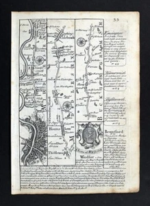
1720 Ogilby Bowen Road Map London Hounslow Maidenhead Henly Abingdon England UK
US $39.99US $39.99
Sun, Sep 21, 07:30 AMSun, Sep 21, 07:30 AM
Picture 1 of 5


Gallery
Picture 1 of 5


Have one to sell?
1720 Ogilby Bowen Road Map London Hounslow Maidenhead Henly Abingdon England UK
US $39.99
Was US $49.99 (20% off)
Condition:
“See the pics and description below. It is a small map, the entire page measures 5 1/2 by 7 3/4 ”... Read moreabout condition
Ended: Sep 21, 2025 07:30:11 PDT
Oops! Looks like we're having trouble connecting to our server.
Refresh your browser window to try again.
Shipping:
US $4.99 USPS Ground Advantage®.
Located in: Fairview, Pennsylvania, United States
Delivery:
Estimated between Fri, Oct 31 and Thu, Nov 6 to 94104
Returns:
30 days returns. Seller pays for return shipping.
Payments:
.
Special financing available. See terms and apply now- for PayPal Credit, opens in a new window or tab
Earn up to 5x points when you use your eBay Mastercard®. Learn moreabout earning points with eBay Mastercard
Shop with confidence
Seller assumes all responsibility for this listing.
eBay item number:365693366875
Item specifics
- Seller Notes
- Engraver
- Bowen
- item
- map
- Printing Technique
- Copper Plate
- Cartographer/Publisher
- John Ogilby
- Publication
- Britannia Depicta or Ogilby Improv'd
- City
- London
- County
- Berkshire, Buckinghamshire, Middlesex, Oxfordshire
- Date Range
- 1700-1799
- Type
- County Map
- Format
- Atlas Map
- Year
- 1720
- Original/Reproduction
- Antique Original
- region
- united kingdom
- Country/Region
- England
Item description from the seller
Seller Feedback
No feedback yet
More to explore :
- London England London Antique Europe Maps & Atlases,
- London England Antique Europe Folding Maps,
- England London Antique Europe Atlas Maps,
- London England Antique Europe City Maps,
- England London Antique Europe City Maps,
- England London Copper Plate Antique Europe Maps & Atlases,
- London Antique European Maps & Atlases England 1800-1899 Date Range,
- London Antique European Maps & Atlases England 1700-1799 Date Range,
- Emanuel Bowen Antique Atlas Maps,
- London London Antique Europe City Maps