
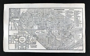
1855 Charles Savage Map Washington DC US Capitol Building Plan Smithsonian City
US $39.99US $39.99
Thu, Oct 02, 06:37 AMThu, Oct 02, 06:37 AM
Picture 1 of 3


Gallery
Picture 1 of 3


Have one to sell?
1855 Charles Savage Map Washington DC US Capitol Building Plan Smithsonian City
US $39.99
Condition:
“Good to Very Good, 4 3/4 by 8 inches (12x20cm) on a 5 1/2 by 9" page (14x23cm), see the pics and ”... Read moreabout condition
Oops! Looks like we're having trouble connecting to our server.
Refresh your browser window to try again.
Shipping:
US $5.99 USPS Ground Advantage®.
Located in: Fairview, Pennsylvania, United States
Delivery:
Estimated between Mon, Nov 3 and Fri, Nov 7 to 94104
Returns:
30 days returns. Seller pays for return shipping.
Payments:
.
Special financing available. See terms and apply now- for PayPal Credit, opens in a new window or tab
Earn up to 5x points when you use your eBay Mastercard®. Learn moreabout earning points with eBay Mastercard
Shop with confidence
Seller assumes all responsibility for this listing.
eBay item number:365603158596
Item specifics
- Seller Notes
- Cartographer/Publisher
- Charles Savage
- Printing Technique
- Woodcut
- Original/Reproduction
- Antique Original
- Format
- Atlas Map
- Topic
- Maps
- Publication Year
- 1830
- Type
- City Map
- Year
- 1855
- US State
- DC, DE, MD, NJ, NY, PA
- Date Range
- 1800-1899
- City
- Washington DC
- Country/Region
- United States of America
Item description from the seller
Seller Feedback
No feedback yet
More to explore :
- Washington Washington Antique North America City Maps,
- Washington City Map Antique North America Atlas Maps,
- Washington Antique North America City Maps,
- District of Columbia Washington Antique North America City Maps,
- New York Washington Antique North America City Maps,
- City Map Antique Atlas Maps,
- City Map Antique Folding Maps,
- City Map Antique Asia Folding Maps,
- City Map Antique Asia Atlas Maps,
- Washington Washington Antique North America River Maps