
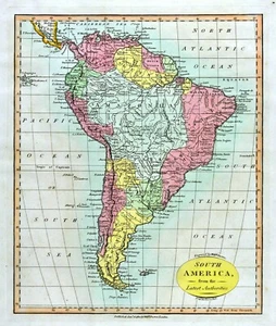
1812 Darton Union Atlas Map South America Brazil Amazon Argentina Chile Peru
US $80.00US $80.00
Sun, Nov 02, 08:16 PMSun, Nov 02, 08:16 PM
Picture 1 of 6


Gallery
Picture 1 of 6


Have one to sell?
1812 Darton Union Atlas Map South America Brazil Amazon Argentina Chile Peru
US $80.00
Was US $100.00 (20% off)
Condition:
“Good to Very Good for its age, from William Darton's "Union Atlas," 9 by 11 inches (23x28cm) on a 12 ”... Read moreabout condition
Ended: Nov 02, 2025 20:16:53 PST
Oops! Looks like we're having trouble connecting to our server.
Refresh your browser window to try again.
Shipping:
US $4.99 USPS Ground Advantage®.
Located in: Fairview, Pennsylvania, United States
Delivery:
Estimated between Sat, Nov 29 and Sat, Dec 6 to 94104
Returns:
30 days returns. Seller pays for return shipping.
Payments:
.
Special financing available. See terms and apply now- for PayPal Credit, opens in a new window or tab
Earn up to 5x points when you use your eBay Mastercard®. Learn moreabout earning points with eBay Mastercard
Shop with confidence
About this item
Seller assumes all responsibility for this listing.
eBay item number:365578481095
Item specifics
- Seller Notes
- Cartographer/Publisher
- William Darton
- Printing Technique
- Copper Plate
- Original/Reproduction
- Antique Original
- Format
- Atlas Map
- Type
- Political Map
- Year
- 1812
- City
- Rio de Janeiro
- Date Range
- 1800-1899
- Country/Region
- Argentina, Bolivia, Brazil, Chile, Colombia, Ecuador, Falkland Islands, French Guiana, Guyana, Paraguay, Peru, Uruguay, Venezuela
Item description from the seller
Seller Feedback
No feedback yet
More to explore :
- Peru Antique South America Atlas Maps,
- Argentina Antique South America Atlas Maps,
- Chile Antique South America Atlas Maps,
- Brazil Antique South America Atlas Maps,
- Brazil Lithography Antique South America Atlas Maps,
- Brazil Antique Original Antique South America Atlas Maps,
- Argentina 1800-1899 Date Range Antique South America Atlas Maps,
- Brazil 1800-1899 Date Range Antique South America Atlas Maps,
- Physical Map Antique South America Atlas Maps,
- Political Map Antique South America Atlas Maps