
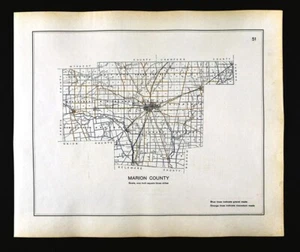
1910 Ohio Highway Road Map Marion County Morral Waldo Prospect La Rue Caledonia
US $28.00US $28.00
Sun, Sep 21, 05:56 PMSun, Sep 21, 05:56 PM
Picture 1 of 5


Gallery
Picture 1 of 5


Have one to sell?
1910 Ohio Highway Road Map Marion County Morral Waldo Prospect La Rue Caledonia
US $28.00
or Best Offer
Was US $35.00 (20% off)
Condition:
“Very Good to Excellent, printed on a strong buff off white page, light tonal ageing with slight ”... Read moreabout condition
Ended: Sep 21, 2025 17:56:25 PDT
Oops! Looks like we're having trouble connecting to our server.
Refresh your browser window to try again.
Shipping:
US $4.99 USPS Ground Advantage®.
Located in: Fairview, Pennsylvania, United States
Delivery:
Estimated between Sat, Nov 29 and Fri, Dec 5 to 94104
Returns:
30 days returns. Seller pays for return shipping.
Payments:
Special financing available. See terms and apply now- for PayPal Credit, opens in a new window or tab
Earn up to 5x points when you use your eBay Mastercard®. Learn moreabout earning points with eBay Mastercard
Shop with confidence
About this item
Seller assumes all responsibility for this listing.
eBay item number:365566438018
Item specifics
- Seller Notes
- Date Range
- 1910-1919
- Type
- Road Atlas
- Format
- Atlas Map
- US State
- IL, IN, MI, OH, WI, Ohio
- Printing Technique
- Lithography
- Year
- 1910
- Original/Reproduction
- Antique Original
- Country/Region
- United States of America
Item description from the seller
Seller Feedback
No feedback yet
More to explore :
- Ohio 1910-1919 Date Range Antique North America County Maps,
- Ohio Antique North America County Maps,
- Ohio County Map Antique North America Atlas Maps,
- Ohio County Map Antique North America Folding Maps,
- Richmond Ohio Antique North America County Maps,
- Ohio Contemporary Antique North America County Maps,
- 1910-1919 Date Range County Map Antique North America Folding Maps,
- Vintage Reproduction 1910-1919 Date Range Antique County Maps,
- AR, IA, KS, LA, MO, NE 1910-1919 Date Range Antique North America County Maps,
- Ohio 1500-1599 Date Range Antique North America County Maps