
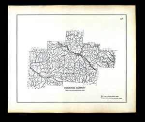
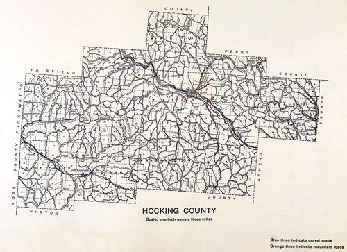
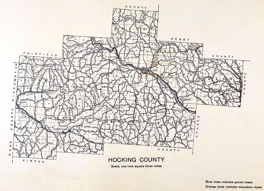
1910 Ohio Highway Road Map Hocking County Logan Carbon Hill Rockbridge Gore OH
US $25.60US $25.60
Wed, Sep 10, 09:37 PMWed, Sep 10, 09:37 PM
Picture 1 of 5


Gallery
Picture 1 of 5


Have one to sell?
1910 Ohio Highway Road Map Hocking County Logan Carbon Hill Rockbridge Gore OH

US $25.60
Was US $32.00 (20% off)
Condition:
“Very Good to Excellent, printed on a strong buff off white page, light tonal ageing with slight ”... Read moreabout condition
Ended: Sep 10, 2025 21:37:36 PDT
Oops! Looks like we're having trouble connecting to our server.
Refresh your browser window to try again.
Shipping:
US $4.99 USPS Ground Advantage®.
Located in: Fairview, Pennsylvania, United States
Delivery:
Estimated between Mon, Nov 10 and Fri, Nov 14 to 94104
Returns:
30 days returns. Seller pays for return shipping.
Payments:
Special financing available. See terms and apply now- for PayPal Credit, opens in a new window or tab
Earn up to 5x points when you use your eBay Mastercard®. Learn moreabout earning points with eBay Mastercard
Shop with confidence
Seller assumes all responsibility for this listing.
eBay item number:365564938355
Item specifics
- Seller Notes
- Date Range
- 1910-1919
- Type
- Road Atlas
- Format
- Atlas Map
- US State
- IL, IN, MI, OH, WI, Ohio
- Printing Technique
- Lithography
- Year
- 1910
- Original/Reproduction
- Antique Original
- Country/Region
- United States of America
Item description from the seller

Popular categories from this store
Seller feedback (20,072)
This item (1)
All items (20,072)
- eBay automated feedback- Feedback left by buyer.Past 6 monthsOrder delivered on time with no issues
- 9***c (120)- Feedback left by buyer.Past monthVerified purchaseExtremely fast shipping. The price was incredible. This seller is on top of their game and I’m definitely going to be buying from them again in the future. Perfectly package said that the documents inside would not be damaged. Even better as described. If you’re looking for the best value on historic documents, this is the place.
- b***w (81)- Feedback left by buyer.Past monthVerified purchaseExcellent buying experience with rapid. Low cost shipping. This delicate map was packaged extremely well. It is just as described in the listing. A true value. I will purchase more from this seller.
- 1***m (15)- Feedback left by buyer.Past 6 monthsVerified purchaseVendor good to deal with, second or third time I have bought from them. Item as descried and in good condition Safely packed Delivery time good. Recommend vendor1869 Bartholomew Map Queensland Cape York Melville Brisbane Cairns Australia (#405337580929)
More to explore :
- Ohio 1910-1919 Date Range Antique North America County Maps,
- Ohio Antique North America County Maps,
- Ohio County Map Antique North America Atlas Maps,
- Ohio County Map Antique North America Folding Maps,
- Richmond Ohio Antique North America County Maps,
- Cincinnati Ohio Antique North America County Maps,
- 1910-1919 Date Range Antique County Maps,
- Ohio Antique Original Antique North America County Maps,
- Vintage Reproduction Ohio Antique North America County Maps,
- IL, IN, MI, OH, WI Antique North America County Maps
Popular categories from this store
Seller feedback (20,072)
This item (1)
All items (20,072)
- eBay automated feedback- Feedback left by buyer.Past 6 monthsOrder delivered on time with no issues
- 9***c (120)- Feedback left by buyer.Past monthVerified purchaseExtremely fast shipping. The price was incredible. This seller is on top of their game and I’m definitely going to be buying from them again in the future. Perfectly package said that the documents inside would not be damaged. Even better as described. If you’re looking for the best value on historic documents, this is the place.
- b***w (81)- Feedback left by buyer.Past monthVerified purchaseExcellent buying experience with rapid. Low cost shipping. This delicate map was packaged extremely well. It is just as described in the listing. A true value. I will purchase more from this seller.
- 1***m (15)- Feedback left by buyer.Past 6 monthsVerified purchaseVendor good to deal with, second or third time I have bought from them. Item as descried and in good condition Safely packed Delivery time good. Recommend vendor1869 Bartholomew Map Queensland Cape York Melville Brisbane Cairns Australia (#405337580929)