
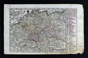
1786 Johann Probst Map Germany Holland Belgium Austria Vienna Berlin Poland Ulm
US $80.00US $80.00
Sat, Sep 20, 06:12 PMSat, Sep 20, 06:12 PM
Picture 1 of 4


Gallery
Picture 1 of 4


Have one to sell?
1786 Johann Probst Map Germany Holland Belgium Austria Vienna Berlin Poland Ulm
US $80.00
Was US $100.00 (20% off)
Condition:
“Good condition for its age, the entire page measures approximately 7 1/2 by 11 3/4 inches (20x30cm). ”... Read moreabout condition
Ended: Sep 20, 2025 18:12:27 PDT
Oops! Looks like we're having trouble connecting to our server.
Refresh your browser window to try again.
Shipping:
US $4.99 USPS Ground Advantage®.
Located in: Fairview, Pennsylvania, United States
Delivery:
Estimated between Tue, Nov 4 and Mon, Nov 10 to 94104
Returns:
30 days returns. Seller pays for return shipping.
Payments:
.
Special financing available. See terms and apply now- for PayPal Credit, opens in a new window or tab
Earn up to 5x points when you use your eBay Mastercard®. Learn moreabout earning points with eBay Mastercard
Shop with confidence
Seller assumes all responsibility for this listing.
eBay item number:365300846482
Item specifics
- Seller Notes
- Cartographer/Publisher
- Johann Probst Map
- Printing Technique
- Copper Plate
- Original/Reproduction
- Antique Original
- Format
- Atlas Map
- Type
- Political Map
- Year
- 1786
- Date Range
- 1700-1799
- City
- Vienna
- Country/Region
- Austria, Belgium, Italy, Germany, Holland, France, Poland
- State
- Berlin
Item description from the seller
Seller Feedback
No feedback yet
More to explore :
- Austria Vienna Antique Europe City Maps,
- Austria Vienna Antique Europe Atlas Maps,
- Antique European Maps & Atlases Vienna Austria,
- Berlin Germany Berlin Antique Europe Maps & Atlases,
- Berlin Poland Antique Europe Maps & Atlases,
- Vienna Antique European Maps & Atlases 1800-1899 Date Range Austria,
- Berlin Germany Copper Plate Antique Europe Maps & Atlases,
- Berlin Antique European Maps & Atlases 1910-1919 Date Range Germany,
- Berlin Antique European Maps & Atlases 1900-1909 Date Range Germany,
- Poland Antique Europe Political Maps