
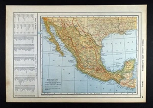
1919 Poates Map Mexico City Puebla Merida Guadalajara Monterrey Tepic Railroads
US $15.99US $15.99
Sun, Oct 05, 06:21 PMSun, Oct 05, 06:21 PM
Picture 1 of 4


Gallery
Picture 1 of 4


Have one to sell?
1919 Poates Map Mexico City Puebla Merida Guadalajara Monterrey Tepic Railroads
US $15.99
or Best Offer
Was US $19.99 (20% off)
Condition:
“Very Good condition, see the pics and description below”
Ended: Oct 05, 2025 18:21:39 PDT
Oops! Looks like we're having trouble connecting to our server.
Refresh your browser window to try again.
Shipping:
US $4.99 USPS Ground Advantage®.
Located in: Fairview, Pennsylvania, United States
Delivery:
Estimated between Mon, Dec 8 and Thu, Dec 11 to 94104
Returns:
30 days returns. Seller pays for return shipping.
Payments:
Special financing available. See terms and apply now- for PayPal Credit, opens in a new window or tab
Earn up to 5x points when you use your eBay Mastercard®. Learn moreabout earning points with eBay Mastercard
Shop with confidence
About this item
Seller assumes all responsibility for this listing.
eBay item number:365272068100
Item specifics
- Seller Notes
- “Very Good condition, see the pics and description below”
- Printing Technique
- Lithography
- US State
- OK, TX, Texas
- Cartographer/Publisher
- Poates
- City
- Mexico City
- Publication Year
- 1919
- Date Range
- 1910-1919
- Type
- State Map
- Format
- Atlas Map
- Mexican State
- Aguascalientes, Baja California, Baja California Sur, Campeche, Chiapas, Chihuahua, Colima, Durango, Guanajuato, Hidalgo, Morelos, Nuevo León, Puebla, Querétaro, Quintana Roo, San Luis Potosí, Sonora, Tabasco, Veracruz, Yucatán, Zacatecas
- Year
- 1919
- Original/Reproduction
- Antique Original
- Topic
- Maps
- Country/Region
- Mexico
Item description from the seller
Seller Feedback
No feedback yet
More to explore :
- Mexico City Antique North America City Maps,
- Mexico Antique North America City Maps,
- Mexico City Antique North America Maps & Atlases,
- 1910-1919 Date Range City Map Antique Sheet Maps,
- 1910-1919 Date Range Antique City Maps,
- 1910-1919 Date Range Antique Railroad Maps,
- France 1910-1919 Date Range Antique Europe City Maps,
- Netherlands 1910-1919 Date Range Antique Europe City Maps,
- Lithography 1910-1919 Date Range Antique Europe City Maps,
- 1910-1919 Date Range Antique North America City Maps