Picture 1 of 2

Gallery
Picture 1 of 2


Have one to sell?
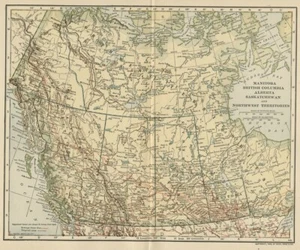
Manitoba, BC, Canada & NW Territories Map; Genuine 1906 (Dated) City Topog Rails

US $25.89
or Best Offer
Condition:
- Buy It NowManitoba, BC, Canada & NW Territories Map; Genuine 1906 (Dated) City Topog Rails
Oops! Looks like we're having trouble connecting to our server.
Refresh your browser window to try again.
Shipping:
Free USPS First Class®.
Located in: Iowa City, Iowa, United States
Delivery:
Estimated between Fri, Oct 31 and Fri, Nov 7 to 94104
Returns:
14 days returns. Buyer pays for return shipping. If you use an eBay shipping label, it will be deducted from your refund amount.
Payments:
Special financing available. See terms and apply now- for PayPal Credit, opens in a new window or tab
Earn up to 5x points when you use your eBay Mastercard®. Learn moreabout earning points with eBay Mastercard
Shop with confidence
Seller assumes all responsibility for this listing.
eBay item number:363253359157
Item specifics
- Type
- Physical Map
- Format
- Atlas Map
- Original/Reproduction
- Antique Original
- Date Range
- 1900-1909
- Country/Region
- Canada
- Canadian Province
- Alberta, British Columbia, Manitoba, Northwest Territories, Saskatchewan
- Printing Technique
- Lithography
- Year
- 1906
- Continent
- North America
- Era
- 1900s
Item description from the seller

Popular categories from this store
Seller feedback (25,035)
- e***8 (40)- Feedback left by buyer.Past 6 monthsVerified purchaseExactly as described and extremely well packagedUGG SIENNA MATTE BLACK WATERPROOF RUBBER WOMEN'S BOOTS SIZE US 8 CLEAN (#135608026169)
- o***u (460)- Feedback left by buyer.Past yearVerified purchaseVery well packaged. Better condition than I was expecting. Quick delivery.OKLAHOMA Map: Authentic 1908 (dated) with Counties Towns Topography Railroads (#365215332602)
- g***g (792)- Feedback left by buyer.Past yearVerified purchaseAs advertised and quick shipping. Thank you! Excellent sellerHUMMINGBIRDS: Authentic 1902 (Dated) Natural History Stone Chromolithograph (#135347179876)
More to explore :
- Manitoba Canada Antique North America Atlas Maps,
- Manitoba Canada Antique North America Maps & Atlases,
- Canada 1800-1899 Date Range Antique North America City Maps,
- Antique North American Maps Manitoba 1900-1909 Date Range Atlases,
- Manitoba George Cram Canada Antique North America Maps & Atlases,
- Antique North American Maps Manitoba 1910-1919 Date Range Atlases,
- Antique North American Maps Manitoba 1930-1939 Date Range Atlases,
- Canada Antique North America City Maps,
- 1500-1599 Date Range Antique City Maps,
- 1920-1929 Date Range Antique City Maps
Popular categories from this store
Seller feedback (25,035)
- e***8 (40)- Feedback left by buyer.Past 6 monthsVerified purchaseExactly as described and extremely well packagedUGG SIENNA MATTE BLACK WATERPROOF RUBBER WOMEN'S BOOTS SIZE US 8 CLEAN (#135608026169)
- o***u (460)- Feedback left by buyer.Past yearVerified purchaseVery well packaged. Better condition than I was expecting. Quick delivery.OKLAHOMA Map: Authentic 1908 (dated) with Counties Towns Topography Railroads (#365215332602)
- g***g (792)- Feedback left by buyer.Past yearVerified purchaseAs advertised and quick shipping. Thank you! Excellent sellerHUMMINGBIRDS: Authentic 1902 (Dated) Natural History Stone Chromolithograph (#135347179876)