Picture 1 of 1
Gallery
Picture 1 of 1

Have one to sell?
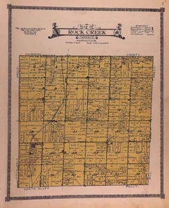
1921 Plat Map ~ ROCK CREEK Township, LANCASTER County, NEBRASKA (14x17)-#03

US $28.88
or Best Offer
Condition:
“This map was printed in 1921, it is not *new* or *new* condition. It was removed from an Antique ”... Read moreabout condition
- Buy It Now1921 Plat Map ~ ROCK CREEK Township, LANCASTER County, NEBRASKA (14x17)-#03
Oops! Looks like we're having trouble connecting to our server.
Refresh your browser window to try again.
Shipping:
Free FedEx Ground Economy®.
Located in: New Braunfels, Texas, United States
Delivery:
Estimated between Mon, Oct 20 and Sat, Oct 25 to 94104
Returns:
30 days returns. Buyer pays for return shipping. If you use an eBay shipping label, it will be deducted from your refund amount.
Payments:
Special financing available. See terms and apply now- for PayPal Credit, opens in a new window or tab
Earn up to 5x points when you use your eBay Mastercard®. Learn moreabout earning points with eBay Mastercard
Shop with confidence
Seller assumes all responsibility for this listing.
eBay item number:357098122109
Item specifics
- Seller Notes
- US State
- Nebraska
- SIZE
- Approx. 14 x 17 inches.
- Color
- Original coloring
- Cartographer/Publisher
- Anderson Publishing Co.
- Date Range
- 1910-1919
- Format
- Plat Map
- Year
- 1921
- S&H
- Free S&H USA - Calculated S&H Worldwide
- Original/Reproduction
- Antique Original
- Land Owners
- Great for ancestry, genealogy & family history research
- Country/Region
- United States of America
- Original
- This map page was printed in 1918.
- Age
- Over 110 years old.
Item description from the seller

Seller feedback (10,027)
- w***3 (408)- Feedback left by buyer.Past 6 monthsVerified purchaseWhat should have been a speedy delivery via Ground Advantage delayed due to the incompetence of the USPS. Item sent from Texas to Chicago, then to Pennsylvania (!), the back to Chicago, finally delivered on July 22. The seller did everything right: prompt shipping, excellent packaging, item as described and worth the price. The score: Seller 10, USPS 0.1862 Map ~ KENTUCKY - TENNESSEE ~ S. Augustus Mitchell (12x15)-#06 (#357251577107)
- o***d (918)- Feedback left by buyer.Past 6 monthsVerified purchaseItem exactly as described and shipped in a very protective package. It took almost 3 weeks for the shipping but the shipping was included in the price. Very good value and worth waiting for. Thank you!1898 City Map ~ PITTSBURGH & ALLEGHENY, PENNSYLVANIA (14x22)-#149 (#357219486507)
- i***a (533)- Feedback left by buyer.Past 6 monthsVerified purchaseExactly as advertised and pleased with how fast seller shipped item and that it encased in a tube for mailing. Pricing was extremely reasonable for such a collectible item. I would certainly buy from this seller again.
More to explore :
- Nebraska Antique North America County Maps,
- Nebraska County Map Antique North America Folding Maps,
- Nebraska County Map Antique North America Atlas Maps,
- Nebraska County Map Antique North America Atlas,
- Nebraska Antique Original Antique North America County Maps,
- Antique County Maps,
- Nebraska 1800-1899 Date Range Antique North America County Maps,
- County Map Antique Europe Atlas Maps,
- County Map Antique Africa Atlas Maps,
- County Map Antique Asia Atlas Maps
Seller feedback (10,027)
- w***3 (408)- Feedback left by buyer.Past 6 monthsVerified purchaseWhat should have been a speedy delivery via Ground Advantage delayed due to the incompetence of the USPS. Item sent from Texas to Chicago, then to Pennsylvania (!), the back to Chicago, finally delivered on July 22. The seller did everything right: prompt shipping, excellent packaging, item as described and worth the price. The score: Seller 10, USPS 0.1862 Map ~ KENTUCKY - TENNESSEE ~ S. Augustus Mitchell (12x15)-#06 (#357251577107)
- o***d (918)- Feedback left by buyer.Past 6 monthsVerified purchaseItem exactly as described and shipped in a very protective package. It took almost 3 weeks for the shipping but the shipping was included in the price. Very good value and worth waiting for. Thank you!1898 City Map ~ PITTSBURGH & ALLEGHENY, PENNSYLVANIA (14x22)-#149 (#357219486507)
- i***a (533)- Feedback left by buyer.Past 6 monthsVerified purchaseExactly as advertised and pleased with how fast seller shipped item and that it encased in a tube for mailing. Pricing was extremely reasonable for such a collectible item. I would certainly buy from this seller again.