Picture 1 of 24


Gallery
Picture 1 of 24


Have one to sell?
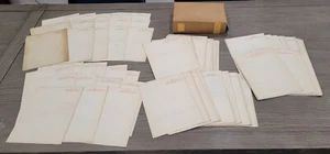
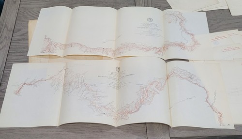
South America Columbia Ecuador Costa Rica Set of Railroad Survey Maps Dated 1893
US $499.99
or Best Offer
as low as $44.89/mo with
Condition:
- Buy It NowSouth America Columbia Ecuador Costa Rica Set of Railroad Survey Maps Dated 1893
Oops! Looks like we're having trouble connecting to our server.
Refresh your browser window to try again.
Pickup:
Free local pickup from Chicago, Illinois, United States 60641
Shipping:
US $8.50 Standard Shipping.
Located in: Chicago, Illinois, United States
Delivery:
Estimated between Wed, Oct 8 and Wed, Oct 15 to 94104
Returns:
Seller does not accept returns.
Payments:
.
*No Interest if paid in full in 6 months on $149+. See terms and apply now- for PayPal Credit, opens in a new window or tab
Earn up to 5x points when you use your eBay Mastercard®. Learn moreabout earning points with eBay Mastercard
Shop with confidence
Seller assumes all responsibility for this listing.
eBay item number:356982075007
Item specifics
- Date Range
- 1800-1899
- Type
- Railroad Map
- Format
- Folding Map
- Year
- 1893
- Original/Reproduction
- Antique Original
- Country/Region
- Colombia, Ecuador
Item description from the seller
Seller feedback (8,633)
- j***6 (3177)- Feedback left by buyer.Past 6 monthsVerified purchaseThe seller packed this $5 photo better than most sellers pack $50 items! Thank you so much! Because of your care in packing, the photo survived all the bodyslams, clotheslines and bumps courtesy of the USPS! Fast and friendly communication too! Many thanks!Signed 1980s Personal WWF Wrestling Photo – Gorgeous Jimmy Garvin and Precious (#356040258230)
- h***6 (35)- Feedback left by buyer.Past 6 monthsVerified purchaseFast shipping, fantastic packaging, as described and great value! Also 10/10 communication, thank you again!
- y***7 (1273)- Feedback left by buyer.Past monthVerified purchaseGroup of English bookplates--safely packaged in layers of paper. Arrived quickly. Very nice discount. All as described!
More to explore :
- Ecuador Antique South America Atlas Maps,
- Ecuador 1800-1899 Date Range Antique South America Atlas Maps,
- Ecuador Antique South America Political Maps,
- Costa Rica 1800-1899 Date Range Antique Central America/Caribbean Maps & Atlases,
- Costa Rica Antique Central America/Caribbean Atlas Maps,
- Ecuador Copper Plate Antique South America Maps & Atlases,
- South Carolina 1800-1899 Date Range Antique North America Railroad Maps,
- 1700-1799 Date Range Antique South America County Maps,
- 1700-1799 Date Range Antique South America Folding Maps,
- 1800-1899 Date Range Antique South America Sheet Maps