
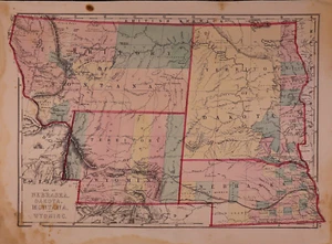
1875 Map ~ NEBRASKA & The TERRITORIES of MONTANA, WYOMING, DAKOTA~ (14x19)-#08
US $215.15US $215.15
Wed, Jul 16, 11:22 AMWed, Jul 16, 11:22 AM
Picture 1 of 3


Gallery
Picture 1 of 3


Have one to sell?
1875 Map ~ NEBRASKA & The TERRITORIES of MONTANA, WYOMING, DAKOTA~ (14x19)-#08
US $215.15
or Best Offer
Was US $228.88 (6% off)
Condition:
“This map is not *new* or *new* condition. It was removed from an Historical Atlas and printed in ”... Read moreabout condition
Ended: Jul 16, 2025 11:22:57 PDT
Oops! Looks like we're having trouble connecting to our server.
Refresh your browser window to try again.
Shipping:
Free USPS Ground Advantage®.
Located in: Schertz, Texas, United States
Delivery:
Estimated between Wed, Oct 15 and Tue, Oct 21 to 94104
Returns:
30 days returns. Buyer pays for return shipping. If you use an eBay shipping label, it will be deducted from your refund amount.
Payments:
.
Earn up to 5x points when you use your eBay Mastercard®. Learn moreabout earning points with eBay Mastercard
Shop with confidence
Seller assumes all responsibility for this listing.
eBay item number:356475965588
Item specifics
- Seller Notes
- Printing Technique
- Lithography
- US State
- Dakota Terrotory, Montana, Nebraska, Wyoming
- Size
- Approx. 14" x 19"
- Cartographer/Publisher
- Charles H. Jones / H. H. Hardesty
- Date Range
- 1800-1899
- Type
- State Map
- Format
- Atlas Map
- Year
- 1875
- S&H
- Free S&H USA - Calculated S&H Worldwide
- Original/Reproduction
- Antique Original
- Country/Region
- United States of America
- Original
- This map page was printed in 1875.
- Age
- Over 140 years old.
Item description from the seller
Seller Feedback
No feedback yet
More to explore :
- Antique North American Maps & Atlases Wyoming,
- Wyoming Antique North America Geological Maps,
- Wyoming Topographical Map Antique North America Folding Maps,
- Wyoming Antique North America Folding Maps,
- Wyoming Antique North America Wall Maps,
- Wyoming Antique North America County Maps,
- Antique North American Maps & Atlases Nebraska,
- Nebraska Topographical Map Antique North America Folding Maps,
- Nebraska Antique North America Folding Maps,
- Nebraska Antique North America City Maps