Picture 1 of 23


Gallery
Picture 1 of 23


Have one to sell?
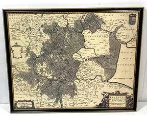
Vintage Historic Old Map Fens Regions Lincolnshire Print On Board Blaeu @1648
GBP 21.99
ApproximatelyUS $29.37
or Best Offer
Condition:
“In good condition for age. No glazing in frame. Some wear on frame edges and a minor nicks on bottom ”... Read moreabout condition
- Buy It NowVintage Historic Old Map Fens Regions Lincolnshire Print On Board Blaeu @1648
Oops! Looks like we're having trouble connecting to our server.
Refresh your browser window to try again.
Shipping:
Located in: St. Ives, United Kingdom
Delivery:
Varies
Returns:
Seller does not accept returns.
Payments:
Earn up to 5x points when you use your eBay Mastercard®. Learn moreabout earning points with eBay Mastercard
Shop with confidence
Seller assumes all responsibility for this listing.
eBay item number:335873079163
Item specifics
- Seller Notes
- Antique
- Yes
- Date Range
- 1600-1699
- Type
- County Map
- Year
- 1648
- Era
- 1600s
- Original/Reproduction
- Vintage Reproduction
- Cartographer/Publisher
- Blaue
- Country/Region
- England
- County
- Cambridgeshire, Lincolnshire, Norfolk, Northamptonshire, Suffolk
Item description from the seller
Seller feedback (183)
- *****- Feedback left by buyer.Past 6 monthsVerified purchaseAn absolutely first-class transaction from start to finish. The crystal bowl is exquisite, as described; packaged with the utmost care and delivered swiftly. Seller’s communication was impeccable throughout—truly a five-star experience. Highly recommended💝
- *****- Feedback left by buyer.Past 6 monthsVerified purchaseExcellent eBayer! Quick response to messages, quick despatch, and packaged such that it could withstand a nuclear bomb (well, almost ...). Glad to have done business with you!
- *****- Feedback left by buyer.Past 6 monthsVerified purchasePostage was really quick, item was well packaged, and was as described in the post. Definitely great value!
This is a private listing and your identity will not be disclosed to anyone except the seller.
More to explore :
- Antique European Maps & Atlases Lincolnshire,
- Willem Blaeu Antique County Maps,
- Willem Blaeu Antique Folding Maps,
- Antique European Maps & Atlases Willem Blaeu,
- Willem Blaeu Antique Maps, Atlases & Globes,
- Willem Blaeu Antique World Maps & Atlases,
- Willem Blaeu Antique Original Antique Maps, Atlases & Globes,
- Willem Blaeu Copper Plate Antique World Folding Maps,
- Willem Blaeu Antique Original Antique World Maps & Atlases 1600-1699 Date Range,
- North Polar Region Antique World Maps & Atlases