Picture 1 of 10


Gallery
Picture 1 of 10


Have one to sell?
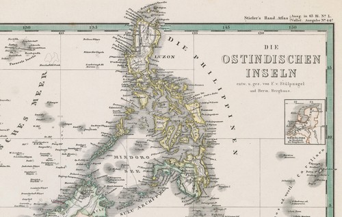
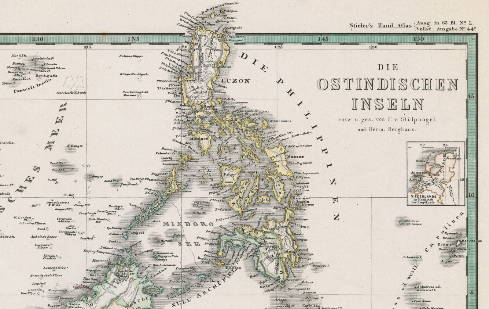
Antique Map "Die Ostindischen Inseln" (Southeast Asia) Stieler - Berghaus, 1870

GBP 125.00
ApproximatelyUS $167.00
or Best Offer
Condition:
- Buy It NowAntique Map "Die Ostindischen Inseln" (Southeast Asia) Stieler - Berghaus, 1870
Oops! Looks like we're having trouble connecting to our server.
Refresh your browser window to try again.
Shipping:
GBP 18.00 (approx US $24.05) International Tracked Postage.
Located in: London, United Kingdom
Delivery:
Estimated between Fri, Oct 17 and Mon, Nov 3 to 94104
Returns:
Seller does not accept returns.
Payments:
Earn up to 5x points when you use your eBay Mastercard®. Learn moreabout earning points with eBay Mastercard
Shop with confidence
Seller assumes all responsibility for this listing.
eBay item number:335501770690
Item specifics
- Antique
- Yes
- Date Range
- 1800-1899
- Type
- Physical Map
- Format
- Sheet Map
- Printing Technique
- Steel Engraving
- Year
- 1870
- Era
- 1800s
- Original/Reproduction
- Antique Original
- Cartographer/Publisher
- Adolf Stieler - Hermann Berghaus
- Country/Region
- Cambodia, Indonesia, Malaysia, Philippines, Thailand, Vietnam
Item description from the seller

Popular categories from this store
Seller feedback (325)
- e***2 (1306)- Feedback left by buyer.Past 6 monthsVerified purchaseExquisite 18th century depiction and gravure of the legendary Bastille by one of the greatest artists of the period and the engraver. Offered at a price point which was generous and more than affordable. This gravure was professionally, expertly packaged—which is a distinct pleasure. It is always pleasing to deal with a professional business in antiquities, as they possess the knowledge in handling fragile, irreplaceable, historical art. Sent securely by Fedex, arriving very quickly. RecommendedAntique Print "A View of the Bastile at Paris" (Bastille) Rigaud, 1749 (#335814097225)
- 9***a (902)- Feedback left by buyer.Past monthVerified purchaseGreat seller! Great engraving! Well packaged. Fast shipping.
- f***5 (5)- Feedback left by buyer.Past yearVerified purchaseQuickly shipped, very well packaged with supporting internal card and plastic. As described and in good condition. Thank you once more. Comes once more with a certificate of authenticity, which is very much appreciated. This is my second map from this gallery and probably won't be the last. Highly recommended.Map "Southern Alps of New Zealand" Royal Geographical Society, 1910 (#334963326798)
More to explore :
- Adolf Stieler Antique Maps, Atlases & Globes,
- Adolf Stieler Antique Original Antique Maps, Atlases & Globes,
- Antique Asia Political Maps,
- Southeast Asia Chinese Antiques,
- Antique Asia Maps & Atlases,
- Antique Asia River Maps,
- Antique Asia Topographical Maps,
- Antique Asia County Maps,
- Physical Map Antique Asia Atlas Maps,
- City Map Antique Asia Folding Maps
Popular categories from this store
Seller feedback (325)
- e***2 (1306)- Feedback left by buyer.Past 6 monthsVerified purchaseExquisite 18th century depiction and gravure of the legendary Bastille by one of the greatest artists of the period and the engraver. Offered at a price point which was generous and more than affordable. This gravure was professionally, expertly packaged—which is a distinct pleasure. It is always pleasing to deal with a professional business in antiquities, as they possess the knowledge in handling fragile, irreplaceable, historical art. Sent securely by Fedex, arriving very quickly. RecommendedAntique Print "A View of the Bastile at Paris" (Bastille) Rigaud, 1749 (#335814097225)
- 9***a (902)- Feedback left by buyer.Past monthVerified purchaseGreat seller! Great engraving! Well packaged. Fast shipping.
- f***5 (5)- Feedback left by buyer.Past yearVerified purchaseQuickly shipped, very well packaged with supporting internal card and plastic. As described and in good condition. Thank you once more. Comes once more with a certificate of authenticity, which is very much appreciated. This is my second map from this gallery and probably won't be the last. Highly recommended.Map "Southern Alps of New Zealand" Royal Geographical Society, 1910 (#334963326798)