
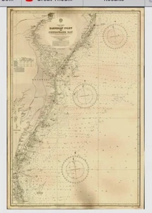
VINTAGE ADMIRALTY CHART. No.266. CHESAPEAKE BAY to BARNEGAT INLET. 1923 Edition.
GBP 29.00GBP 29.00
Wed, Jul 16, 01:53 PMWed, Jul 16, 01:53 PM
Picture 1 of 10


Gallery
Picture 1 of 10


Have one to sell?
VINTAGE ADMIRALTY CHART. No.266. CHESAPEAKE BAY to BARNEGAT INLET. 1923 Edition.
GBP 29.00
ApproximatelyUS $38.74
or Best Offer
Condition:
Oops! Looks like we're having trouble connecting to our server.
Refresh your browser window to try again.
Shipping:
GBP 20.00 (approx US $26.72) Royal Mail International Tracked.
International shipment of items may be subject to customs processing and additional charges.
Located in: Gullane, East Lothian , United Kingdom
Delivery:
Estimated between Mon, Oct 20 and Fri, Oct 31 to 94104
Returns:
Seller does not accept returns.
Payments:
Earn up to 5x points when you use your eBay Mastercard®. Learn moreabout earning points with eBay Mastercard
Shop with confidence
Seller assumes all responsibility for this listing.
eBay item number:335344075060
Item specifics
- Antique
- Yes
- Date Range
- 1920-1929
- Type
- Nautical Map
- US State
- Delaware
- Format
- Sheet Map
- Printing Technique
- Copper Plate
- Year
- 1923
- Original/Reproduction
- Vintage Original
- Cartographer/Publisher
- British Admiralty
- City
- Philadelphia, Cape May.
- Country/Region
- United States of America
Item description from the seller
Seller Feedback
No feedback yet
More to explore :
- Vintage Original Antique Maritime Navigational Charts,
- Canada Vintage Original Antique Maritime Navigational Charts,
- US Navy Vintage Original Antique Maritime Navigational Charts,
- Vietnam War Vintage Original Antique Maritime Navigational Charts,
- United States Vintage Original Antique Maritime Navigational Charts,
- Antique Maritime Navigational Charts,
- WWII Antique Maritime Navigational Charts,
- United Kingdom Antique Maritime Navigational Charts,
- Vietnam War US Navy Antique Maritime Navigational Charts,
- United States Antique Original Antique Maritime Navigational Charts