
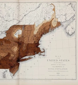
1880 NEW ENGLAND STATES Map DENSITY OF POPULATION Original - DATED (14X10)
US $38.88US $38.88
Sun, Aug 10, 04:47 PMSun, Aug 10, 04:47 PM
Picture 1 of 3


Gallery
Picture 1 of 3


Have one to sell?
1880 NEW ENGLAND STATES Map DENSITY OF POPULATION Original - DATED (14X10)

US $38.88
or Best Offer
Condition:
Oops! Looks like we're having trouble connecting to our server.
Refresh your browser window to try again.
Shipping:
Free USPS Ground Advantage®.
Located in: Carefree, Arizona, United States
Delivery:
Estimated between Thu, Sep 25 and Wed, Oct 1 to 94104
Returns:
30 days returns. Seller pays for return shipping.
Payments:
.
Special financing available. See terms and apply now- for PayPal Credit, opens in a new window or tab
Earn up to 5x points when you use your eBay Mastercard®. Learn moreabout earning points with eBay Mastercard
Shop with confidence
Seller assumes all responsibility for this listing.
eBay item number:326672677700
Item specifics
- Date Range
- 1800-1899
- Type
- Political Map
- Format
- Atlas Map
- Printing Technique
- Lithography
- US State
- Connecticut, Maine, Massachusetts, New Hampshire, New Jersey, New York, Pennsylvania, Rhode Island, Vermont
- Year
- 1880
- Original/Reproduction
- Antique Original
- Cartographer/Publisher
- United States Census Bureau
- City
- Pittsburg
- Country/Region
- United States of America
Item description from the seller

Seller feedback (6,505)
- n***n (147)- Feedback left by buyer.Past monthVerified purchaseI was excited to find the lithograph of Mrs. Ann (Taylor) Reeve, the aunt of my 4th great grandmother. Thank you SELSA84 for making these beautiful pictures available. It was shipped immediately In a couple of days was able to open a well secured cylinder package with the picture inside, 10x better then described and pictured online. Priced very reasonably, but priceless to me. Thank you.
- _***c (130)- Feedback left by buyer.Past 6 monthsVerified purchaseGreat Ebay Seller! My antique map of Colorado arrived in perfect condition ~ Item was as described ~ Item was packaged well ~ Seller combined shipping cost of 4 historical maps purchased ~ Great Value ~ Transaction deserves 5 STARS! Again, thank you.1885 MAP COLORADO - Original (12x9) GEORGE CRAM - Townships Railroads (#226803088841)
- b***w (54)- Feedback left by buyer.Past 6 monthsVerified purchaseExcellent buying experience with rapid shipping. This delicate 161 year old map was packaged extremely well to make the journey to my house without issue or concern. As I review the map, it is just as described in the listing. A true value to my collection and I will purchase more items from the seller. Thank you, selsa84.
More to explore :
- Antique European Maps & Atlases England 1930-1939 Date Range,
- England 1910-1919 Date Range Antique Europe City Maps,
- Antique European Maps & Atlases England 1940-1949 Date Range,
- England 1800-1899 Date Range Antique Europe Sheet Maps,
- England 1700-1799 Date Range Antique Europe Folding Maps,
- England 1600-1699 Date Range Antique Europe Folding Maps,
- England 1920-1929 Date Range Antique Europe City Maps,
- England Vintage Original Antique Europe Maps & Atlases,
- England European Antique Maps & Atlases Cumberland 1800-1899 Date Range,
- London Antique European Maps & Atlases England 1800-1899 Date Range
Seller feedback (6,505)
- n***n (147)- Feedback left by buyer.Past monthVerified purchaseI was excited to find the lithograph of Mrs. Ann (Taylor) Reeve, the aunt of my 4th great grandmother. Thank you SELSA84 for making these beautiful pictures available. It was shipped immediately In a couple of days was able to open a well secured cylinder package with the picture inside, 10x better then described and pictured online. Priced very reasonably, but priceless to me. Thank you.
- _***c (130)- Feedback left by buyer.Past 6 monthsVerified purchaseGreat Ebay Seller! My antique map of Colorado arrived in perfect condition ~ Item was as described ~ Item was packaged well ~ Seller combined shipping cost of 4 historical maps purchased ~ Great Value ~ Transaction deserves 5 STARS! Again, thank you.1885 MAP COLORADO - Original (12x9) GEORGE CRAM - Townships Railroads (#226803088841)
- b***w (54)- Feedback left by buyer.Past 6 monthsVerified purchaseExcellent buying experience with rapid shipping. This delicate 161 year old map was packaged extremely well to make the journey to my house without issue or concern. As I review the map, it is just as described in the listing. A true value to my collection and I will purchase more items from the seller. Thank you, selsa84.