Picture 1 of 2

Gallery
Picture 1 of 2


Have one to sell?
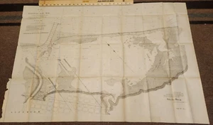
1894 MAP OF ALLOUEZ BAY WISCONSIN 27.50 x 40.50!

US $14.99
Condition:
“Has Pin-Hole Tear on Inside Fold but Map is in Very Good Condition!”
- Buy It Now1894 MAP OF ALLOUEZ BAY WISCONSIN 27.50 x 40.50!
Oops! Looks like we're having trouble connecting to our server.
Refresh your browser window to try again.
Delivery:
Varies
Returns:
Seller does not accept returns.
Payments:
Special financing available. See terms and apply now- for PayPal Credit, opens in a new window or tab
Earn up to 5x points when you use your eBay Mastercard®. Learn moreabout earning points with eBay Mastercard
Shop with confidence
Seller assumes all responsibility for this listing.
eBay item number:326105386275
Item specifics
- Seller Notes
- “Has Pin-Hole Tear on Inside Fold but Map is in Very Good Condition!”
- Date Range
- 1800-1899
- Type
- River Map
- Format
- Folding Map
- US State
- Wisconsin
- Year
- 1894
- Original/Reproduction
- Antique Original
Item description from the seller

Seller Feedback
Error displaying feedback. Try refreshing the page.
More to explore :
- Antique Wisconsin Maps & Atlases,
- Wisconsin Topographical Map Antique North America Folding Maps,
- Wisconsin County Map Antique North America Folding Maps,
- Wisconsin County Map Antique North America Atlas Maps,
- Wisconsin Railroad Map Antique North America Atlas Maps,
- Wisconsin Antique North America Geological Maps,
- Wisconsin Antique North America River Maps,
- Detroit Wisconsin Antique North America Maps & Atlases,
- Lithography Wisconsin Antique North America County Maps,
- New York Wisconsin American Antique Maps & Atlases
Seller Feedback
Error displaying feedback. Try refreshing the page.