Picture 1 of 1
Gallery
Picture 1 of 1

Have one to sell?
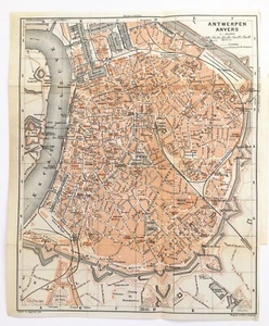
ANTWERP or ANVERS BELGIUM Street City Plan - 1910 Antique Map
GBP 9.99
ApproximatelyUS $13.31
Condition:
- Buy It NowANTWERP or ANVERS BELGIUM Street City Plan - 1910 Antique Map
Oops! Looks like we're having trouble connecting to our server.
Refresh your browser window to try again.
Returns:
Seller does not accept returns.
Payments:
Earn up to 5x points when you use your eBay Mastercard®. Learn moreabout earning points with eBay Mastercard
Shop with confidence
About this item
Seller assumes all responsibility for this listing.
eBay item number:325801636035
Item specifics
- Antique
- Yes
- Era
- 1910s
- Original/Reproduction
- Antique Original
- City
- Antwerp
- Country/Region
- Belgium
Item description from the seller
Seller feedback (6,860)
- l***6 (5795)- Feedback left by buyer.Past 6 monthsVerified purchaseSo happy to purchase from you, thank you! Fast delivery, packaged very well, as described, great communication, recommended seller!Antique 1930 London Map - Mounted - WEST NORWOOD, STREATHAM, TULSE HILL 71 (#326427724305)
- o***l (298)- Feedback left by buyer.Past 6 monthsVerified purchaseThese illustrations are brilliant and will look amazing when framed. Seller was great at communicating, above and beyond customer service. Package arrived on time and carefully wrapped. Could not be happier!
- r***i (92)- Feedback left by buyer.Past 6 monthsVerified purchaseSpeedy delivery, packed perfectly. Beautiful little map exactly as described, and for a great price too! Thanks very much :)
More to explore :
- Belgium Antwerp Antique Europe City Maps,
- Antique European Maps & Atlases Antwerp Belgium,
- Belgium Antwerp Antique Original Antique European Maps & Atlases,
- Antwerp Antique Europe City Maps,
- Belgium 1910-1919 Date Range Antique Europe City Maps,
- Antique European Maps & Atlases Antwerp,
- Antwerp Antique Original Antique European Maps & Atlases,
- Belgium 1600-1699 Date Range Antique Europe City Maps,
- Belgium 1800-1899 Date Range Antique Europe City Maps,
- Belgium Antique Europe Topographical Maps