Picture 1 of 7


Picture 1 of 7


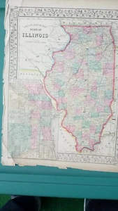
1867 County Map The State of Illinois Mitchell Brothers Atlas & Plan of Chicago

US $49.99
or Best Offer
Condition:
“very good condition. Minimal wear and discoloration along the borders. See the photos, as the item ”... Read moreabout condition
Shipping:
US $11.95 Economy Shipping.
Located in: Swampscott, Massachusetts, United States
Delivery:
Estimated between Sat, Sep 28 and Thu, Oct 3 to 43230
Returns:
30 days returns. Buyer pays for return shipping.
Payments:
Special financing available. See terms and apply now- for PayPal Credit, opens in a new window or tab
Earn up to 5x points when you use your eBay Mastercard®. Learn moreabout earning points with eBay Mastercard
Shop with confidence
Seller assumes all responsibility for this listing.
eBay item number:325377561911
Item specifics
- Seller Notes
- Cartographer/Publisher
- Samuel Augustus Mitchell
- Original/Reproduction
- Antique Original
- Format
- Atlas
- Type
- County Map
- Year
- 1867
- US State
- Illinois
- Date Range
- 1800-1899
- City
- Chicago
- Country/Region
- United States of America
Item description from the seller

More to explore :
- Illinois County Map Antique North America Atlas Maps,
- Illinois County Map Antique North America Atlas,
- Chicago Illinois Antique North America County Maps,
- Chicago Illinois Antique North America Atlas Maps,
- County Map Antique Atlas,
- Illinois Antique North America County Maps,
- Italy County Map Antique Europe Atlas Maps,
- England County Map Antique Europe Atlas Maps,
- France County Map Antique Europe Atlas Maps,
- Greece County Map Antique Europe Atlas Maps