
Picture 1 of 6


Gallery
Picture 1 of 6


Have one to sell?
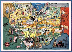
1930s Original Indiana and Illinois Picture Map Berta Elmer Hader State Map 470
US $25.20
Was US $28.00 (10% off)
Condition:
“Rare Illinois and Indiana picture map by Berta and Elmer Hader in very good condition.”
- Buy It Now1930s Original Indiana and Illinois Picture Map Berta Elmer Hader State Map 470
Oops! Looks like we're having trouble connecting to our server.
Refresh your browser window to try again.
Shipping:
US $4.75 USPS Ground Advantage®.
Located in: Harborton, Virginia, United States
Delivery:
Estimated between Fri, Nov 14 and Fri, Nov 21 to 94104
Returns:
30 days returns. Seller pays for return shipping.
Payments:
Special financing available. See terms and apply now- for PayPal Credit, opens in a new window or tab
Earn up to 5x points when you use your eBay Mastercard®. Learn moreabout earning points with eBay Mastercard
Shop with confidence
Seller assumes all responsibility for this listing.
eBay item number:314359457784
Item specifics
- Seller Notes
- “Rare Illinois and Indiana picture map by Berta and Elmer Hader in very good condition.”
- Date Range
- 1930-1939
- Type
- Novelty Map
- Format
- Animated/Picture
- US State
- illinois indiana
- Year
- 1932
- Original/Reproduction
- Antique Original
- Features
- Antique,Vintage
- Topic
- Maps
- Country/Region
- United States of America
Item description from the seller
Seller feedback (26,586)
- -***l (161)- Feedback left by buyer.Past 6 monthsVerified purchaseThis is truly one of the most outstanding eBay interactions I've ever experienced. The Seller provided exceptional communication with great detail and care in explaining the map and its original source. The shipping was cost-effective and extremely well-packaged. I truly feel that the value for what was received, the condition it was in, far exceeded my expectations of what was described.
- 3***b (39)- Feedback left by buyer.Past 6 monthsVerified purchaseExcellent 5 Star Seller, great vintage condition as listed, great price, reasonable shipping cost, requested it be shipped to my brother in another city and arrived as requested. Greatly appreciate the error free experience and I thank you so very much!!1929 Antique ATCHISON Topeka SANTA FE RAILWAY Map Vintage Railroad Map 2285 (#316625517333)
- 3***3 (56)- Feedback left by buyer.Past 6 monthsVerified purchasePackaging was great! Fast shipping. Exactly as described. Great seller and great price. A++++++
More to explore :
- Illinois County Map Antique North America Folding Maps,
- Illinois City Map Antique North America Atlas Maps,
- Illinois County Map Antique North America Atlas Maps,
- Illinois Topographical Map Antique North America Folding Maps,
- Illinois Railroad Map Antique North America Atlas Maps,
- Illinois Vintage Original Antique North America Folding Maps,
- Illinois Antique Original Antique North America River Maps,
- Illinois Antique Original Antique North America Railroad Maps,
- 1930-1939 Date Range Folding Map River Map Antique Maps, Atlases & Globes,
- Physical Map Sheet Map Antique 1930-1939 Date Range Maps, Atlases & Globes