Picture 1 of 1
Picture 1 of 1

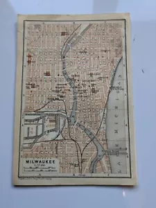
1909 map street plan of Milwaukee Wisconsin USA antique vintage Baedeker

GBP 6.00
ApproximatelyUS $7.93
or Best Offer
Condition:
“Minor grubby marks, rough page edge”
Shipping:
GBP 3.25 (approx US $4.29) Royal Mail International Standard.
International shipment of items may be subject to customs processing and additional charges.
Located in: Horncastle, United Kingdom
Delivery:
Estimated between Thu, Sep 26 and Wed, Oct 2 to 43230
Please allow additional time if international delivery is subject to customs processing.
Returns:
14 days returns. Buyer pays for return shipping.
Payments:
Earn up to 5x points when you use your eBay Mastercard®. Learn moreabout earning points with eBay Mastercard
Shop with confidence
Seller assumes all responsibility for this listing.
eBay item number:296378237337
Item specifics
- Seller Notes
- “Minor grubby marks, rough page edge”
- Antique
- Yes
- Date Range
- 1900-1909
- Type
- Topographical Map
- Printing Technique
- Lithography
- Format
- Atlas Map
- US State
- Wisconsin
- Year
- 1909
- Era
- 1900s
- Original/Reproduction
- Antique Original
- Cartographer/Publisher
- Karl Baedeker
- City
- Milwaukee
- Country/Region
- North America, United States of America
Item description from the seller

Popular categories from this store
Seller feedback (444)
- o***4 (183)- Feedback left by buyer.Past 6 monthsVerified purchaseThis vendor was a pleasure to deal with. Questions were promptly answered. Request for availability of other maps was answered promptly and fully. Maps arrived packaged with care and safety. The products purchased were better than expected. And I was issued a partial refund on the postage based on multiple purchases. Thank you!!!! EFBc1895 county map of Worcestershire antique vintage Britannica 9th (#296405467491)
- b***0 (101)- Feedback left by buyer.Past 6 monthsVerified purchaseQuick delivery, as described, well packaged. Would recommend seller, thanks!
- m***m (388)- Feedback left by buyer.Past 6 monthsVerified purchaseItem exactly as described, carefully packaged and rapid delivery with refreshingly honest p&p Cracking service, highly recommended.County map of Dorsetshire England hand coloured c1860 (#296339780867)
More to explore :
- Antique Wisconsin Maps & Atlases,
- Wisconsin Antique North America Maps & Atlases 1900-1909 Date Range,
- Wisconsin 1900-1909 Date Range Antique North America County Maps,
- Wisconsin 1900-1909 Date Range Antique North America Atlas Maps,
- Vintage Reproduction Antique North American Maps for Wisconsin,
- Wisconsin Antique North America County Maps,
- Wisconsin County Map Antique North America Atlas Maps,
- Wisconsin Antique North America Railroad Maps,
- Wisconsin Railroad Map Antique North America Atlas Maps,
- Wisconsin Antique Original Antique North America County Maps