Picture 1 of 12


Picture 1 of 12


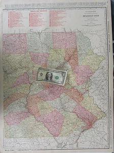
XL 1916 EASTERN PENNSYLVANIA RAILROAD Wall Map. McNally COMMERCIAL. PA 1910s.

US $26.47
Condition:
“See listing.”
Shipping:
US $6.97 USPS Ground Advantage®.
Located in: Bluffton, Indiana, United States
Delivery:
Estimated between Thu, Sep 26 and Fri, Sep 27 to 43230
Returns:
14 days returns. Buyer pays for return shipping.
Payments:
Special financing available. See terms and apply now- for PayPal Credit, opens in a new window or tab
Earn up to 5x points when you use your eBay Mastercard®. Learn moreabout earning points with eBay Mastercard
Shop with confidence
Seller assumes all responsibility for this listing.
eBay item number:285619319725
Item specifics
- Seller Notes
- “See listing.”
- Cartographer/Publisher
- Rand McNally & Co.
- Original/Reproduction
- Original
- Format
- Atlas Map
- Maker
- Rand McNally Commercial
- Topic
- Maps
- Publication Year
- 1916
- Type
- Railroad Map
- Year
- 1916
- US State
- Pennsylvania
- Date Range
- 1910-1919
- Country/Region
- United States of America
Item description from the seller
This is a private listing and your identity will not be disclosed to anyone except the seller.
More to explore :
- Rand McNally & Co. 1910-1919 Date Range Antique Railroad Maps,
- Pennsylvania 1910-1919 Date Range Antique North America Railroad Maps,
- Pennsylvania Antique North America Railroad Maps,
- Rand McNally & Co. Antique Wall Maps,
- Rand McNally & Co. 1910-1919 Date Range Antique North America Railroad Maps,
- Railroad Map Antique Wall Maps,
- Rand McNally & Co. World Antique World Wall Maps,
- Rand McNally & Co. 1910-1919 Date Range Antique Atlas Maps,
- Rand McNally & Co. 1910-1919 Date Range Antique Topographical Maps,
- 1910-1919 Date Range Antique Railroad Maps