
Picture 1 of 4


Gallery
Picture 1 of 4


Have one to sell?
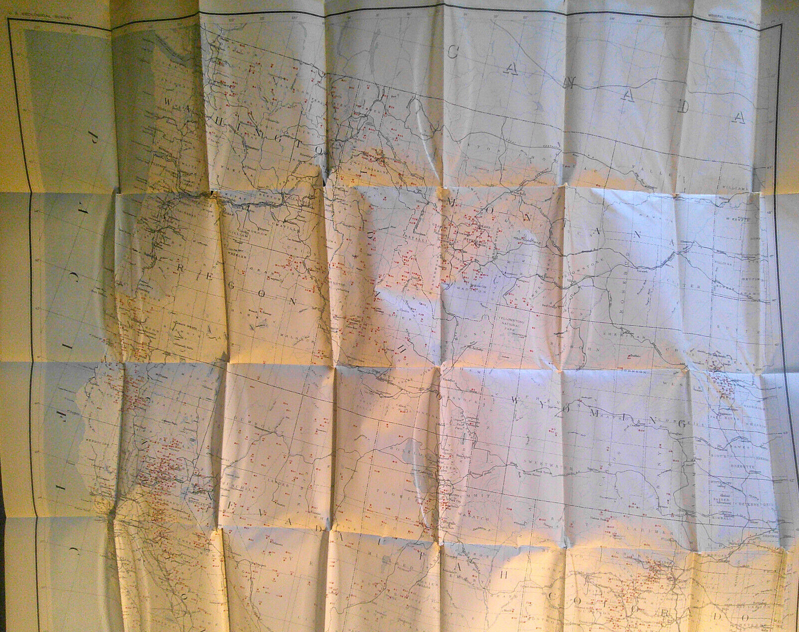
1907 Map of the Mining Districts of the Western States, by Waldemar Lindgren.
US $156.00
Was US $195.00 (20% off)
as low as $27.07/mo with
Condition:
“Very Good. A few puncture holes at folds.”
- Buy It Now1907 Map of the Mining Districts of the Western States, by Waldemar Lindgren.
Oops! Looks like we're having trouble connecting to our server.
Refresh your browser window to try again.
Shipping:
US $58.70 UPS Ground.
Located in: New York, New York, United States
Delivery:
Estimated between Wed, Dec 10 and Tue, Dec 16 to 94104
Returns:
30 days returns. Buyer pays for return shipping. If you use an eBay shipping label, it will be deducted from your refund amount.
Payments:
.
*No Interest if paid in full in 6 months on $149+. See terms and apply now- for PayPal Credit, opens in a new window or tab
Earn up to 5x points when you use your eBay Mastercard®. Learn moreabout earning points with eBay Mastercard
Shop with confidence
About this item
Seller assumes all responsibility for this listing.
eBay item number:276823838590
Item specifics
- Seller Notes
- “Very Good. A few puncture holes at folds.”
- Date Range
- 1900-1909
- Format
- Folding Map
- Printing Technique
- Lithography
- Year
- 1907
- Original/Reproduction
- Antique Original
- Country/Region
- United States of America
Item description from the seller
Popular categories from this store
Seller feedback (1,755)
- a***z (324)- Feedback left by buyer.Past 6 monthsVerified purchaseAwesome Seller. Responsive to questions, quick to ship, well packaged to protect item. Positive all around.The American Twins, Labor & Capital, by Nast. Harper's Weekly, February 7, 1874 (#276387860985)
- 1***m (1757)- Feedback left by buyer.Past monthVerified purchaseSpedizione veloce, buona comunicazione e oggetto come da descrizione. Venditore altamente consigliato. Thanks!
- g***w (543)- Feedback left by buyer.Past monthVerified purchaseShipped fast, packaged well, as described, good value, thank you! A+
More to explore :
- District of Columbia United States of America Antique North America City Maps,
- District of Columbia United States of America Antique North America Atlas Maps,
- District of Columbia United States of America Antique North American Maps & Atlases,
- District of Columbia City Map Antique North America Atlas Maps,
- District of Columbia Antique North America Atlas Maps,
- District of Columbia Maryland Antique North America Maps & Atlases,
- Western Hemisphere Antique World Physical Maps,
- District of Columbia 1960-1969 Date Range Antique North America Maps & Atlases,
- Mining Antiques,
- United States of America Nautical Map Antique North America Folding Maps