Picture 1 of 3


Gallery
Picture 1 of 3


Have one to sell?
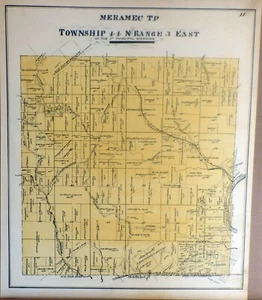
1893 - Map - Township 44 N Range 3 East - Meramec TP; St. Louis County, Mo.

US $24.95
Condition:
“See Description”
- Buy It Now1893 - Map - Township 44 N Range 3 East - Meramec TP; St. Louis County, Mo.
Oops! Looks like we're having trouble connecting to our server.
Refresh your browser window to try again.
Pickup:
Free local pickup from Saint Louis, Missouri, United States 63129
Shipping:
US $6.65 USPS Ground Advantage®.
Located in: Saint Louis, Missouri, United States
Delivery:
Estimated between Wed, Oct 29 and Tue, Nov 4 to 94104
Returns:
30 days returns. Buyer pays for return shipping. If you use an eBay shipping label, it will be deducted from your refund amount.
Payments:
Special financing available. See terms and apply now- for PayPal Credit, opens in a new window or tab
Earn up to 5x points when you use your eBay Mastercard®. Learn moreabout earning points with eBay Mastercard
Shop with confidence
Seller assumes all responsibility for this listing.
eBay item number:276066274591
Item specifics
- Seller Notes
- “See Description”
- Date Range
- 1800-1899
- Type
- County Map
- Printing Technique
- Engraving
- US State
- Missouri
- Format
- Atlas Map
- Year
- 1893
- Original/Reproduction
- Antique Original
- Cartographer/Publisher
- Berkley E. Johnson / C. R. Black
- City
- Meramec T"P - Townsip 44 N. Range 3 East
- Topic
- Maps
- Country/Region
- United States of America
Item description from the seller

Seller feedback (2,825)
- 2***r (4391)- Feedback left by buyer.Past 6 monthsVerified purchaseVery happy with this purchase! A great find! All as described and shown. Shipped promptly and safely packaged in a clear plastic sleeve inside 2 cardboard boards and red DO NOT BEND stickers on the outside white plastic envelope. A+A+War in Italy - Birds Eye View of the City of Alessandria - 1859 Historical Print (#275479743131)
- i***p (321)- Feedback left by buyer.Past yearVerified purchaseI highly recommend this eBay seller. Item was exactly as described, very well & thoughtfully packed. Shipped promptly by the seller. Thank you! The Postal Service, however, was not so prompt, taking 12 days for delivery.Bealington, on Beverley Pike Near Laurel Hill, Western Va. - Civil War - 1861 (#282293025384)
- t***e (359)- Feedback left by buyer.Past 6 monthsVerified purchaseGreat Seller. Excellent packaging. Quick shipping. Product as described. Thank you!
More to explore :
- St. Louis Antique North America County Maps,
- St. Louis Missouri Antique North America County Maps,
- 1910-1919 Date Range County Map Antique Folding Maps,
- 1970-1979 Date Range Antique County Maps,
- 1800-1899 Date Range County Map Antique Sheet Maps,
- 1920-1929 Date Range County Map Antique Folding Maps,
- 1920-1929 Date Range Antique County Maps,
- 1400-1499 Date Range Antique County Maps,
- 1930-1939 Date Range Antique County Maps,
- Antique County Maps
Seller feedback (2,825)
- 2***r (4391)- Feedback left by buyer.Past 6 monthsVerified purchaseVery happy with this purchase! A great find! All as described and shown. Shipped promptly and safely packaged in a clear plastic sleeve inside 2 cardboard boards and red DO NOT BEND stickers on the outside white plastic envelope. A+A+War in Italy - Birds Eye View of the City of Alessandria - 1859 Historical Print (#275479743131)
- i***p (321)- Feedback left by buyer.Past yearVerified purchaseI highly recommend this eBay seller. Item was exactly as described, very well & thoughtfully packed. Shipped promptly by the seller. Thank you! The Postal Service, however, was not so prompt, taking 12 days for delivery.Bealington, on Beverley Pike Near Laurel Hill, Western Va. - Civil War - 1861 (#282293025384)
- t***e (359)- Feedback left by buyer.Past 6 monthsVerified purchaseGreat Seller. Excellent packaging. Quick shipping. Product as described. Thank you!