
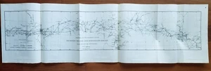
1890 US Coast & Geodetic Survey Map # 6 Between Ohio & Mississippi Rivers
US $40.00US $40.00
Thu, Sep 04, 01:03 PMThu, Sep 04, 01:03 PM
Picture 1 of 5


Gallery
Picture 1 of 5


Have one to sell?
1890 US Coast & Geodetic Survey Map # 6 Between Ohio & Mississippi Rivers
US $40.00
or Best Offer
Condition:
“Excellent condition.”
Oops! Looks like we're having trouble connecting to our server.
Refresh your browser window to try again.
Shipping:
US $5.80 USPS First Class®.
Located in: Santa Barbara, California, United States
Delivery:
Estimated between Wed, Oct 8 and Sat, Oct 11 to 94104
Returns:
Seller does not accept returns.
Payments:
.
Special financing available. See terms and apply now- for PayPal Credit, opens in a new window or tab
Earn up to 5x points when you use your eBay Mastercard®. Learn moreabout earning points with eBay Mastercard
Shop with confidence
Seller assumes all responsibility for this listing.
eBay item number:266490105425
Item specifics
- Seller Notes
- “Excellent condition.”
- Date Range
- 1800-1899
- Type
- Geodetic Map
- Format
- Sheet Map
- Printing Technique
- Lithography
- US State
- Ohio & Mississippi Rivers
- Year
- 1890
- Special Attributes
- Huge Map Measuring 40" x 11"
- Original/Reproduction
- Antique Original
- Cartographer/Publisher
- United States Government
- City
- Antique Original Map
- Country/Region
- United States of America
Item description from the seller
Seller Feedback
No feedback yet
More to explore :
- Mississippi Antique North America River Maps,
- Mississippi River Map Antique North America Folding Maps,
- Ohio Antique North America River Maps,
- Ohio River Map Antique North America Folding Maps,
- Lithography Mississippi Antique North America River Maps,
- Antique Europe Ordnance Survey Maps,
- Antique Asia River Maps,
- Antique North American Maps & Atlases Mississippi,
- Contemporary Antique River Maps,
- Antique Europe River Maps