
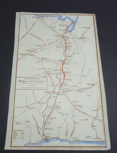
Antique Map of Hadrian's Wall by John Cary 1813
GBP 45.00GBP 45.00
Wed, Nov 26, 12:30 AMWed, Nov 26, 12:30 AM
Picture 1 of 5


Gallery
Picture 1 of 5


Have one to sell?
Antique Map of Hadrian's Wall by John Cary 1813

GBP 45.00
ApproximatelyUS $59.25
or Best Offer
Condition:
“Antique Original”
Oops! Looks like we're having trouble connecting to our server.
Refresh your browser window to try again.
Shipping:
GBP 10.00 (approx US $13.17) Royal Mail International Signed.
International shipment of items may be subject to customs processing and additional charges.
Located in: Bath, United Kingdom
Delivery:
Estimated between Thu, Dec 11 and Wed, Dec 17 to 94104
Returns:
Seller does not accept returns.
Payments:
Earn up to 5x points when you use your eBay Mastercard®. Learn moreabout earning points with eBay Mastercard
Shop with confidence
About this item
Seller assumes all responsibility for this listing.
eBay item number:256839446121
Item specifics
- Seller Notes
- “Antique Original”
- Country of Origin
- United Kingdom
- Date Range
- 1800-1899
- Type
- Topographical Map
- Printing Technique
- Copper Plate
- Format
- Sheet Map
- Year
- 1813
- Era
- 1800s
- Cartographer/Publisher
- John Cary
- Original/Reproduction
- Antique Original
- Country/Region
- England
Item description from the seller

Seller feedback (523)
- s***b (102)- Feedback left by buyer.Past 6 monthsVerified purchaseThis fine example of Cary's ability as an engraver was delivered within three days of being ordered was exactly as described and arrived well-protected in a robust cardboard tube - not even a postage charge! Thankyou, Michael, for running your business at such a high standard of service.Antique Map of Bedfordshire by John Cary 1789 (#254765838170)
- e***e (457)- Feedback left by buyer.Past 6 monthsVerified purchaseThe map arrived safely in its tube and within a very short time. I have not actually opened it yet as it's a present and the recipient is staying with me, but I'm sure it'll be fine. If not, I'll add another review. Postage was very reasonable and packaging could not have been better. Also, great value for money!
- n***e (1778)- Feedback left by buyer.Past 6 monthsVerified purchaseTerrific seller! Lovely print, well packaged and quickly shipped. Thank you!!Antique print of Greenwich and Deptford by Alexander Hogg 1784 (#256839351011)
More to explore :
- John Cary Antique Atlas Maps,
- Antique European Maps & Atlases John Cary,
- John Cary Antique Maps, Atlases & Globes,
- John Cary Antique Europe Atlas Maps,
- John Cary Antique Original Antique Maps, Atlases & Globes,
- Antique Wall Maps,
- Railroad Map Antique Wall Maps,
- Nautical Map Antique Wall Maps,
- Antique Original Topographical Map Antique Wall Maps,
- Antique Original County Map Antique Wall Maps
Seller feedback (523)
- s***b (102)- Feedback left by buyer.Past 6 monthsVerified purchaseThis fine example of Cary's ability as an engraver was delivered within three days of being ordered was exactly as described and arrived well-protected in a robust cardboard tube - not even a postage charge! Thankyou, Michael, for running your business at such a high standard of service.Antique Map of Bedfordshire by John Cary 1789 (#254765838170)
- e***e (457)- Feedback left by buyer.Past 6 monthsVerified purchaseThe map arrived safely in its tube and within a very short time. I have not actually opened it yet as it's a present and the recipient is staying with me, but I'm sure it'll be fine. If not, I'll add another review. Postage was very reasonable and packaging could not have been better. Also, great value for money!
- n***e (1778)- Feedback left by buyer.Past 6 monthsVerified purchaseTerrific seller! Lovely print, well packaged and quickly shipped. Thank you!!Antique print of Greenwich and Deptford by Alexander Hogg 1784 (#256839351011)