Picture 1 of 4


Gallery
Picture 1 of 4


Have one to sell?
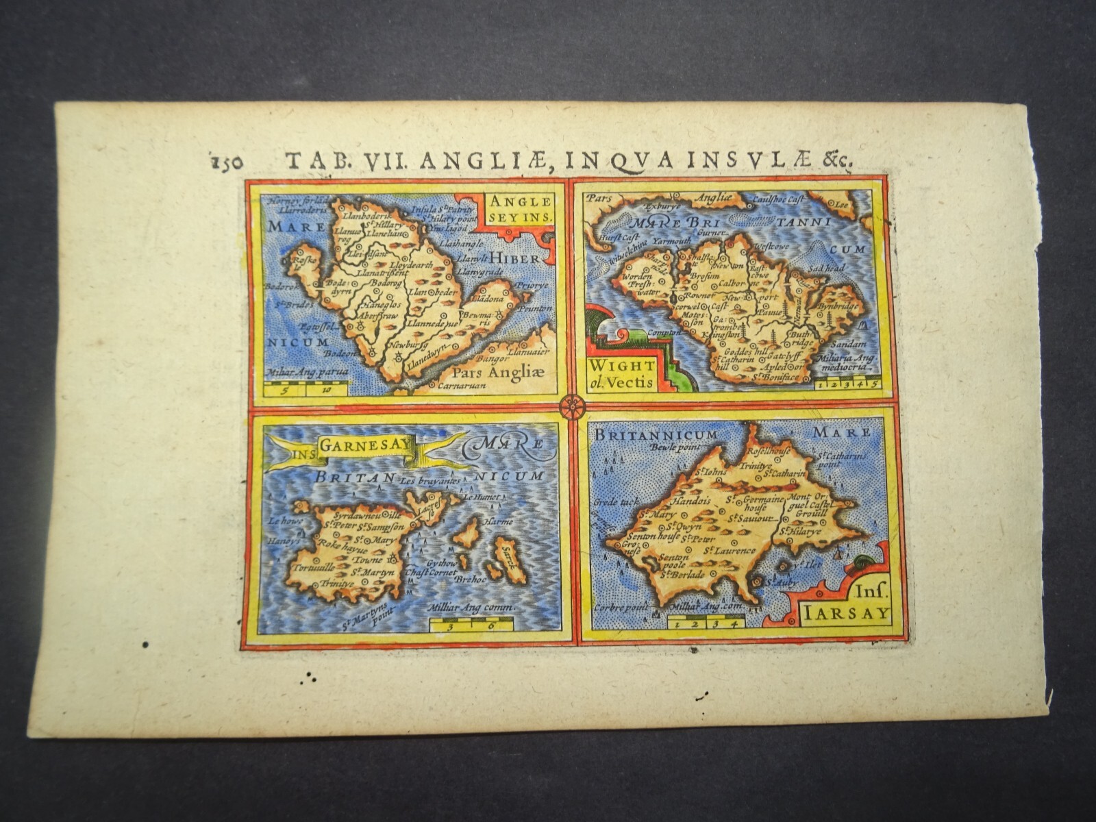
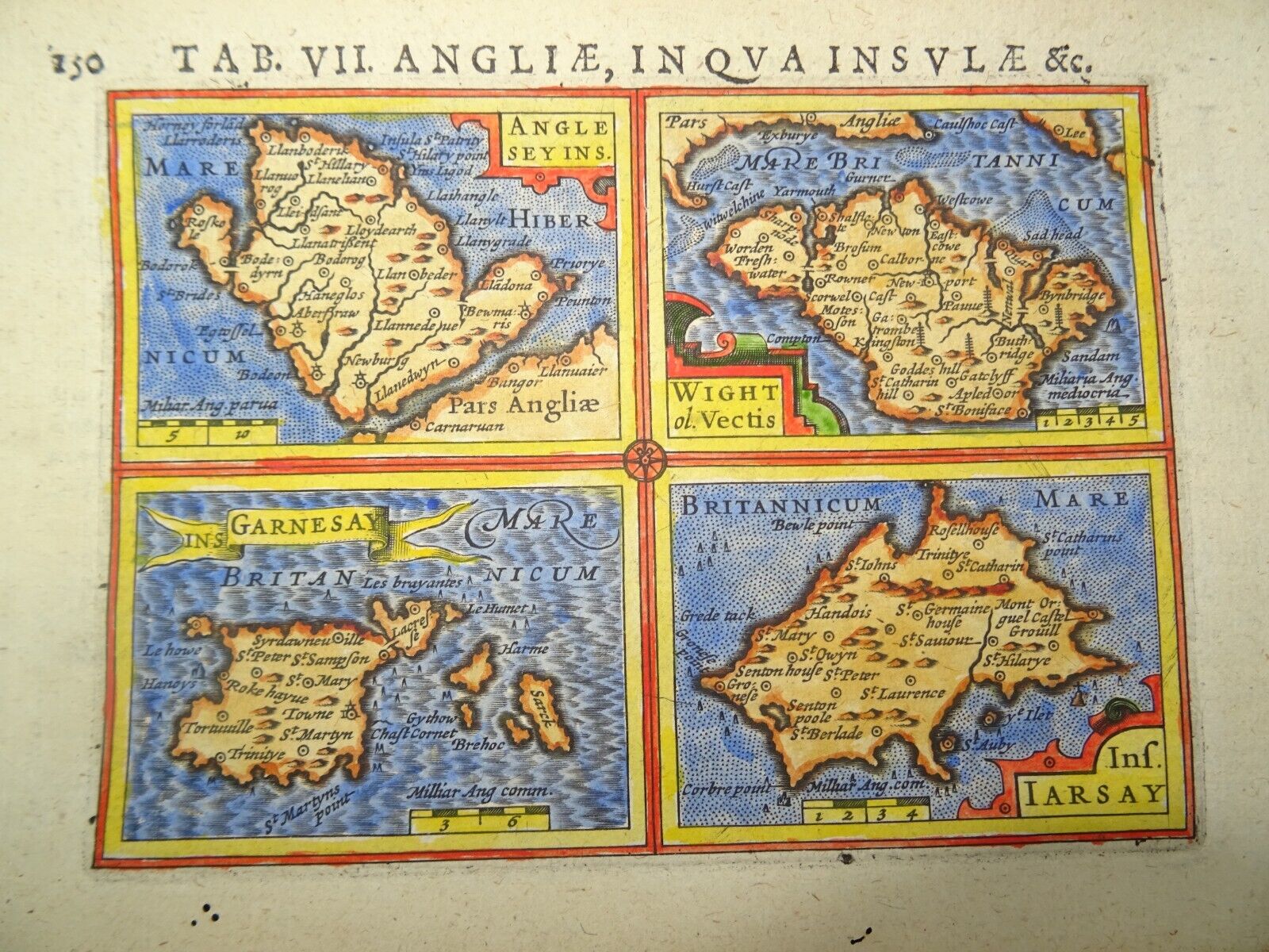
Antique Map of the English Islands by Petrus Bertius 1618

GBP 85.00
ApproximatelyUS $114.96
Condition:
- Buy It NowAntique Map of the English Islands by Petrus Bertius 1618
Oops! Looks like we're having trouble connecting to our server.
Refresh your browser window to try again.
Shipping:
GBP 10.00 (approx US $13.53) Royal Mail International Signed.
International shipment of items may be subject to customs processing and additional charges.
Located in: Bath, United Kingdom
Delivery:
Estimated between Mon, Sep 8 and Wed, Sep 17 to 94104
Returns:
Seller does not accept returns.
Payments:
Earn up to 5x points when you use your eBay Mastercard®. Learn moreabout earning points with eBay Mastercard
Shop with confidence
Seller assumes all responsibility for this listing.
eBay item number:256487252938
Item specifics
- Date Range
- 1600-1699
- Type
- Topographical Map
- Printing Technique
- Copper Plate
- Year
- 1618
- Era
- 1600s
- Cartographer/Publisher
- Petrus Bertius
- Original/Reproduction
- Antique Original
- Country/Region
- England
- County
- Anglesey, Isle of Wight, Guernsey, Jersey
Item description from the seller

Seller feedback (491)
- s***b (102)- Feedback left by buyer.Past monthVerified purchaseThis fine example of Cary's ability as an engraver was delivered within three days of being ordered was exactly as described and arrived well-protected in a robust cardboard tube - not even a postage charge! Thankyou, Michael, for running your business at such a high standard of service.
- n***e (1756)- Feedback left by buyer.Past monthVerified purchaseTerrific seller! Lovely print, well packaged and quickly shipped. Thank you!!
- 0***1 (1595)- Feedback left by buyer.Past 6 monthsVerified purchaseReceived OK, great map, well packaged, easy transaction, A1.
More to explore :
- Rhode Island County Map Antique North America Atlas Maps,
- Antique South American Maps & Atlases Falkland Islands,
- Rhode Island Antique North America Nautical Maps,
- Marshall Islands Antique Australia/Oceania Maps & Atlases,
- Rhode Island Antique North America Folding Maps,
- Rhode Island Antique North America County Maps,
- Falkland Islands Antique Original Antique South America Maps & Atlases,
- Virgin Islands Antique Central American/Caribbean Maps & Atlases,
- Rhode Island Contemporary Antique North America Maps & Atlases,
- Providence Rhode Island Antique North America City Maps
Seller feedback (491)
- s***b (102)- Feedback left by buyer.Past monthVerified purchaseThis fine example of Cary's ability as an engraver was delivered within three days of being ordered was exactly as described and arrived well-protected in a robust cardboard tube - not even a postage charge! Thankyou, Michael, for running your business at such a high standard of service.
- n***e (1756)- Feedback left by buyer.Past monthVerified purchaseTerrific seller! Lovely print, well packaged and quickly shipped. Thank you!!
- 0***1 (1595)- Feedback left by buyer.Past 6 monthsVerified purchaseReceived OK, great map, well packaged, easy transaction, A1.