Picture 1 of 6


Gallery
Picture 1 of 6


Have one to sell?
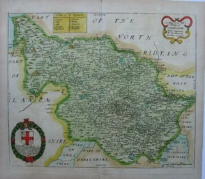
Antique map of Yorkshire West Riding by Richard Blome 1673

GBP 95.00
ApproximatelyUS $127.55
Condition:
- Buy It NowAntique map of Yorkshire West Riding by Richard Blome 1673
Oops! Looks like we're having trouble connecting to our server.
Refresh your browser window to try again.
Shipping:
GBP 5.00 (approx US $6.71) Royal Mail International Signed.
Located in: Bath, United Kingdom
Delivery:
Estimated between Thu, Oct 23 and Mon, Nov 3 to 94104
Returns:
Seller does not accept returns.
Payments:
Earn up to 5x points when you use your eBay Mastercard®. Learn moreabout earning points with eBay Mastercard
Shop with confidence
Seller assumes all responsibility for this listing.
eBay item number:254428254868
Item specifics
- County
- Yorkshire
- Cartographer/Publisher
- Richard Blome
- Printing Technique
- Copper Plate
- Original/Reproduction
- Antique Original
- Type
- Topographical Map
- Year
- 1673
- Date Range
- 1600-1699
- Country/Region
- England
- Era
- 1600s
- Country/Region of Manufacture
- United Kingdom
Item description from the seller

Seller feedback (506)
- s***b (102)- Feedback left by buyer.Past 6 monthsVerified purchaseThis fine example of Cary's ability as an engraver was delivered within three days of being ordered was exactly as described and arrived well-protected in a robust cardboard tube - not even a postage charge! Thankyou, Michael, for running your business at such a high standard of service.
- e***e (443)- Feedback left by buyer.Past monthVerified purchaseThe map arrived safely in its tube and within a very short time. I have not actually opened it yet as it's a present and the recipient is staying with me, but I'm sure it'll be fine. If not, I'll add another review. Postage was very reasonable and packaging could not have been better. Also, great value for money!
- n***e (1766)- Feedback left by buyer.Past 6 monthsVerified purchaseTerrific seller! Lovely print, well packaged and quickly shipped. Thank you!!
More to explore :
- Antique European Maps & Atlases Yorkshire,
- Yorkshire Antique Original Antique European Maps & Atlases,
- Antique European Maps & Atlases England Yorkshire,
- England Yorkshire Antique Original Antique European Maps & Atlases,
- Antique European Maps & Atlases Yorkshire 1800-1899 Date Range,
- England European Antique Maps & Atlases Yorkshire 1800-1899 Date Range,
- West Virginia Antique North America Maps & Atlases,
- West Virginia Vintage Original Antique North America Topographical Maps,
- Antique Atlas Maps,
- Antique Original Political Map Antique Wall Maps
Seller feedback (506)
- s***b (102)- Feedback left by buyer.Past 6 monthsVerified purchaseThis fine example of Cary's ability as an engraver was delivered within three days of being ordered was exactly as described and arrived well-protected in a robust cardboard tube - not even a postage charge! Thankyou, Michael, for running your business at such a high standard of service.
- e***e (443)- Feedback left by buyer.Past monthVerified purchaseThe map arrived safely in its tube and within a very short time. I have not actually opened it yet as it's a present and the recipient is staying with me, but I'm sure it'll be fine. If not, I'll add another review. Postage was very reasonable and packaging could not have been better. Also, great value for money!
- n***e (1766)- Feedback left by buyer.Past 6 monthsVerified purchaseTerrific seller! Lovely print, well packaged and quickly shipped. Thank you!!