Picture 1 of 12


Gallery
Picture 1 of 12


Have one to sell?
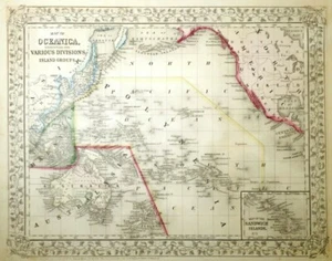
MID-19TH C ANTIQUE 1866 MAP OCEANICA ISLAND GROUPS/ASIA BY AUGUSTUS MITCHELL JR.

US $267.50
or Best Offer
as low as $46.42/mo with
Condition:
“Good-Very Good overall antique cond: No tears, paper loss, noticeable stains, permutations, corner ”... Read moreabout condition
- Buy It NowMID-19TH C ANTIQUE 1866 MAP OCEANICA ISLAND GROUPS/ASIA BY AUGUSTUS MITCHELL JR.
Oops! Looks like we're having trouble connecting to our server.
Refresh your browser window to try again.
Pickup:
Free local pickup from Milford, New Hampshire, United States 03055
Shipping:
US $61.55 USPS Ground Advantage®.
Located in: Milford, New Hampshire, United States
Delivery:
Estimated between Wed, Aug 27 and Wed, Sep 3 to 94104
Returns:
30 days returns. Buyer pays for return shipping. If you use an eBay shipping label, it will be deducted from your refund amount.
Payments:
.
As low as $46.42/mo with Klarna.
*No Interest if paid in full in 6 months on $149+. See terms and apply now- for PayPal Credit, opens in a new window or tab
Earn up to 5x points when you use your eBay Mastercard®. Learn moreabout earning points with eBay Mastercard
Shop with confidence
Seller assumes all responsibility for this listing.
eBay item number:254353092215
Item specifics
- Seller Notes
- Mid-19th century
- Dated 1866
- American
- Antique
- Cartographer/Publisher
- Augstus Mitchell Jr. (American, 19th c)
- Printing Technique
- Woodcut
- Original/Reproduction
- Antique Original
- Post US Civil War
- American cartographer/geographer
- Hand-painted w/watercolor paint
- Large folio
- Most likely previously in bound atlas
- Printed on paper
- Format
- Atlas Map
- Type
- Pacific oceanic map, including island groups
- Year
- 1866
- Date Range
- 1800-1899
- Country/Region
- Australia, Cook Islands, Fiji, French Polynesia, Guam, Kiribati, Marshall Islands, Micronesia, Nauru
Item description from the seller

Seller feedback (1,755)
- s***5 (1117)- Feedback left by buyer.Past 6 monthsVerified purchaseTruly a most beautiful basket in pristine condition! I’m delighted with this purchase and Pleased to display it with my collection of early American baskets. Aptly described, offered at a favorable price point, carefully packaged to ensure safe delivery without damage and received promptly! This is a dealer whom I would highly recommend and look forward to doing more business with in the future ! Thanks
- b***q (2258)- Feedback left by buyer.Past monthVerified purchaseQuick shipping ! Very well packaged! Item as described! Fair value for market! Great eBayer! Thank you!
- o***l (4142)- Feedback left by buyer.Past monthVerified purchaseItem was as described and was EXTREMELY WELL PACKED and shipped quickly. Worth the shipping fee to ensure it's safe arrival. Definitely RECOMMEND this 5 STAR seller all the way.
More to explore :
- Samuel Augustus Mitchell Antique Atlas Maps,
- Samuel Augustus Mitchell Antique County Maps,
- Samuel Augustus Mitchell Antique Original Antique County Maps,
- Antique European Maps & Atlases Samuel Augustus Mitchell,
- Samuel Augustus Mitchell Lithography Antique Atlas Maps,
- Samuel Augustus Mitchell Antique Original Antique Atlas Maps,
- Samuel Augustus Mitchell Copper Plate Antique Atlas Maps,
- Antique Asia Political Maps,
- Antique Asia Maps & Atlases,
- Samuel Augustus Mitchell Antique Original Antique Maps, Atlases & Globes 1800-1899 Date Range
Seller feedback (1,755)
- s***5 (1117)- Feedback left by buyer.Past 6 monthsVerified purchaseTruly a most beautiful basket in pristine condition! I’m delighted with this purchase and Pleased to display it with my collection of early American baskets. Aptly described, offered at a favorable price point, carefully packaged to ensure safe delivery without damage and received promptly! This is a dealer whom I would highly recommend and look forward to doing more business with in the future ! Thanks
- b***q (2258)- Feedback left by buyer.Past monthVerified purchaseQuick shipping ! Very well packaged! Item as described! Fair value for market! Great eBayer! Thank you!
- o***l (4142)- Feedback left by buyer.Past monthVerified purchaseItem was as described and was EXTREMELY WELL PACKED and shipped quickly. Worth the shipping fee to ensure it's safe arrival. Definitely RECOMMEND this 5 STAR seller all the way.