Picture 1 of 1
Stock photo

Picture 1 of 1
Stock photo
National Geographic Reference Map Ser.: World - National Geographic by National Geographic Maps Staff (2022, Sheet Map, Rolled)

ZUBER (274767)
98% positive feedback
Price:
$37.95
Free shipping
Returns:
30 days returns. Seller pays for return shipping.
Condition:
NATIONAL GEOGRAPHIC: WORLD EXECUTIVE WALL MAP (36 X 24 INCHES) (NATIONAL GEOGRAPHIC REFERENCE MAP) By National Geographic Maps - Reference **BRAND NEW**.
- Buy It NowNATIONAL GEOGRAPHIC: WORLD EXECUTIVE WALL MAP (36 X 24 By National Geographic
Oops! Looks like we're having trouble connecting to our server.
Refresh your browser window to try again.
About this product
Product Identifiers
PublisherNational Geographic Maps
ISBN-101597752088
ISBN-139781597752084
eBay Product ID (ePID)204290132
Product Key Features
Number of Pages1 Pages
LanguageEnglish
Publication NameWorld-National Geographic
Publication Year2022
SubjectEarth Sciences / Geography, Atlases, Gazetteers & Maps (See Also Travel / Maps & Road Atlases), Reference, Science
TypeMap
AuthorNational Geographic Maps Staff
SeriesNational Geographic Reference Map Ser.
FormatSheet Map, Rolled
Dimensions
Item Weight5.5 Oz
Item Length25.2 in
Item Width2.2 in
Additional Product Features
Edition Number2022
Intended AudienceTrade
IllustratedYes
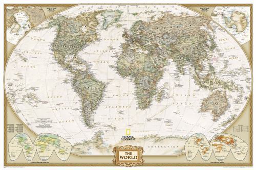
SynopsisThe most up-to-date executive world map from the cartographers at National Geographic, in a smaller poster size. This map features the Winkel Tripel projection to reduce distortion of land masses as they near the poles. Features an antique-style colour palette for a more upscale look. Separate insets show the North and South Polar Regions, world vegetation and land use, and world population density. Scale 1:45,500,000. Tubed. 91.4 x 61 cm., Expertly researched and designed, National Geographic's World Wall Map is the authoritative map of the world by which other reference maps are measured. Product Features: Antique-style "executive" color palette Background shows mountain ranges and valleys in subtle shaded relief with mountain ranges labeled Major water bodies including rivers, lakes, glaciers, oceans, seas, gulfs, bays, straits, and bathymetry Clearly defined international boundaries , cities, islands, airports, and physical features Thousands of place names carefully and artfully placed to maintain legibility in heavily populated areas Up-to-date international boundaries and territorial control reflect de facto status on the ground Meticulously researched using multiple authoritative sources including the U.N., U.S. Board on Geographic Names, and policies of individual governments. Accurate place names use a combination of conventional English names, official national names, and standard transliterations for non-Latin alphabets. Drawn in Winkel Tripel projection with distortions minimized unlike other World maps (e.g. Greenland is shown the same size as Argentina, not South America) Corner inset maps feature vegetation, land use, population density, and north and south polar regions The 36" x 24" poster size supports easy and affordable framing and mounting, and takes less wall space than standard wall maps.The map is packaged in a two inch diameter tube with a label showing a thumbnail of the map with dimensions and other pertinent information. Map Scale = 1:37,215,000 Sheet Size = 36" x 24", National Geographic's World map is the standard by which all other reference maps are measured. The World map is meticulously researched and adheres to National Geographic's convention of making independent, apolitical decisions based on extensive research using multiple authoritative source, The Executive style World map uses an antique-style color palette and stunning shaded relief that provide a richness perfect for any decor. Drawn in the Winkel Tripel projection, distortions are minimized and unlike many other World maps, Greenland is show the same size as Argentina and not as the size of all of South America. Thousands of place names are carefully and artistically placed on the map to maintain legibility even in the heavily populated ares of Europe, Asia and the Middle East. Details include clearly defined international boundaries, cities, physical features, rivers, and ocean floor features. Corner inset maps feature vegetation and land use, and population density as well as the north and south polar regions. Poster sized maps make a perfect addition to any sized space. They are specially designed to maximize content in a smaller footprint than standard wall maps and fit precisely into precut poster sized frames which makes finishing and hanging them a breeze. The map is packaged in a two inch diamater clear plastic tube. The tube has a decorative label showing a thumbnail of the map with dimensions and other pertinent information. Map Scale = 1:37,215,000 Sheet Size = 36" x 24"
All listings for this product


Be the first to write a review


