Picture 1 of 1
Gallery
Picture 1 of 1

Have one to sell?
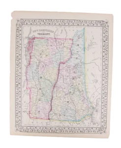
1870 Antique New Hampshire & Vermont State Atlas Map by Mitchell

US $29.95
or Best Offer
Condition:
“See Image for Condition”
- Buy It Now1870 Antique New Hampshire & Vermont State Atlas Map by Mitchell
Oops! Looks like we're having trouble connecting to our server.
Refresh your browser window to try again.
Shipping:
US $9.95 Standard Shipping.
Located in: Fremont, New Hampshire, United States
Delivery:
Estimated between Fri, Oct 17 and Wed, Oct 22 to 94104
Returns:
Seller does not accept returns.
Payments:
Special financing available. See terms and apply now- for PayPal Credit, opens in a new window or tab
Earn up to 5x points when you use your eBay Mastercard®. Learn moreabout earning points with eBay Mastercard
Shop with confidence
Seller assumes all responsibility for this listing.
eBay item number:236082991474
Item specifics
- Seller Notes
- “See Image for Condition”
- Date Range
- 1800-1899
- US State
- New Hampshire, Vermont
- Format
- Atlas Map
- Year
- 1870
- Original/Reproduction
- Antique Original
- Cartographer/Publisher
- Samuel Augustus Mitchell
- Country/Region
- United States of America
Item description from the seller

Popular categories from this store
Seller feedback (435)
- b***r (1860)- Feedback left by buyer.Past 6 monthsVerified purchaseAmazing seller, great pricing, everything came packaged well and as described. Shipping was reasonable and seller communicated very well. Top Notch!1989 G.I. Joe Spirit Slaughters Marauders Action Figure & File Card by Hasbro (#235924209544)
- d***e (1344)- Feedback left by buyer.Past 6 monthsVerified purchaseFast shipping Packed well Great value Figure is as described
- a***e (37)- Feedback left by buyer.Past monthVerified purchaseItem was as described and arrived in protective packaging in a timely manner.
More to explore :
- New Hampshire Antique North America Atlas Maps,
- United States of America New Hampshire Antique North America Atlas Maps,
- New Hampshire Antique Original Antique North America Atlas Maps,
- Lithography New Hampshire Antique North America Atlas Maps,
- New Hampshire County Map Antique North America Atlas,
- Vermont Lithography Antique North America Atlas Maps,
- Antique North American Maps & Atlases New Hampshire,
- New Hampshire Antique North America Wall Maps,
- New Hampshire Antique North America City Maps,
- New Hampshire Topographical Map Antique North America Folding Maps
Popular categories from this store
Seller feedback (435)
- b***r (1860)- Feedback left by buyer.Past 6 monthsVerified purchaseAmazing seller, great pricing, everything came packaged well and as described. Shipping was reasonable and seller communicated very well. Top Notch!1989 G.I. Joe Spirit Slaughters Marauders Action Figure & File Card by Hasbro (#235924209544)
- d***e (1344)- Feedback left by buyer.Past 6 monthsVerified purchaseFast shipping Packed well Great value Figure is as described
- a***e (37)- Feedback left by buyer.Past monthVerified purchaseItem was as described and arrived in protective packaging in a timely manner.