
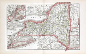
1886 NEW YORK STATE Map ORIGINAL (18x12) LARGE Townships County RAILROADS
US $46.00US $46.00
Sat, May 31, 01:16 PMSat, May 31, 01:16 PM
Picture 1 of 6


Gallery
Picture 1 of 6


Have one to sell?
1886 NEW YORK STATE Map ORIGINAL (18x12) LARGE Townships County RAILROADS
US $46.00
or Best Offer
Condition:
“Good condition”
Oops! Looks like we're having trouble connecting to our server.
Refresh your browser window to try again.
Shipping:
Free USPS Ground Advantage®.
Located in: Monroe, Georgia, United States
Delivery:
Estimated between Tue, Aug 26 and Tue, Sep 2 to 94104
Returns:
30 days returns. Seller pays for return shipping.
Payments:
.
Special financing available. See terms and apply now- for PayPal Credit, opens in a new window or tab
Earn up to 5x points when you use your eBay Mastercard®. Learn moreabout earning points with eBay Mastercard
Shop with confidence
Seller assumes all responsibility for this listing.
eBay item number:226771046387
Item specifics
- Seller Notes
- “Good condition”
- Date Range
- 1800-1899
- Type
- Railroad Map
- US State
- New York
- Format
- Atlas Map
- Printing Technique
- Lithography
- Year
- 1886
- Original/Reproduction
- Antique Original
- Cartographer/Publisher
- Donohue and Henneberry
- City
- Brooklyn
- Country/Region
- United States of America
Item description from the seller
Seller Feedback
No feedback yet
More to explore :
- New York Antique Original Antique North America County Maps,
- New York New York Antique North America County Maps,
- United States of America New York Antique North America County Maps,
- New York United States of America Antique North America County Maps,
- New York Antique North America County Maps,
- New York County Map Antique North America Atlas Maps,
- Lithography New York Antique North America County Maps,
- Rochester New York Antique North America County Maps,
- New York Railroad Map Antique North America Atlas Maps,
- Antique Original Antique County Maps