
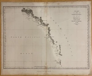
1798 La Perouse Chart of the North West Coast of America Boussole 1st Sheet
US $314.99US $314.99
Thu, Aug 28, 03:44 AMThu, Aug 28, 03:44 AM
Picture 1 of 2

Gallery
Picture 1 of 2


Have one to sell?
1798 La Perouse Chart of the North West Coast of America Boussole 1st Sheet
US $314.99
or Best Offer
Condition:
““This is an Original Antique Map from the year stated in title. All of our maps are stored in ”... Read moreabout condition
Oops! Looks like we're having trouble connecting to our server.
Refresh your browser window to try again.
Shipping:
US $8.95 USPS Ground Advantage®.
Located in: Galway, New York, United States
Save on combined shipping
Delivery:
Estimated between Thu, Nov 6 and Thu, Nov 13 to 94104
Returns:
30 days returns. Buyer pays for return shipping. If you use an eBay shipping label, it will be deducted from your refund amount.
Payments:
.
Earn up to 5x points when you use your eBay Mastercard®. Learn moreabout earning points with eBay Mastercard
Shop with confidence
Seller assumes all responsibility for this listing.
eBay item number:226533901680
Item specifics
- Seller Notes
- Date Range
- 1700-1799
- Type
- Chart/Map
- Format
- Atlas Map
- Printing Technique
- Copper Plate
- Year
- 1798
- Original/Reproduction
- Antique Original
- Cartographer/Publisher
- G.G. & J. Robinson
- Country/Region
- United States of America
Item description from the seller
Seller Feedback
No feedback yet
More to explore :
- Antique North America Sheet Maps,
- North Dakota Antique North America Sheet Maps,
- North Carolina Antique North America Sheet Maps,
- United States of America North Carolina Antique North America Sheet Maps,
- United States of America Antique North America Sheet Maps,
- West Virginia Antique North America Maps & Atlases,
- Maryland Antique North America Sheet Maps,
- Canada Antique North America Sheet Maps,
- Arkansas Antique North America Sheet Maps,
- Georgia Antique North America Sheet Maps