Picture 1 of 7


Gallery
Picture 1 of 7


Have one to sell?
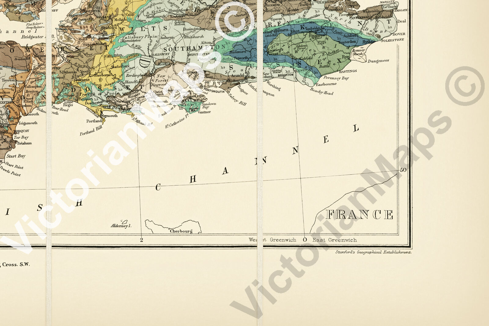
UK British Isles Great Britain geological map Best & Stanford 1893 print poster

GBP 23.70
ApproximatelyUS $32.18
Condition:
5 available1 sold
- Buy It NowUK British Isles Great Britain geological map Best & Stanford 1893 print poster
Oops! Looks like we're having trouble connecting to our server.
Refresh your browser window to try again.
Shipping:
GBP 22.40 (approx US $30.41) Royal Mail International Tracked & Signed.
International shipment of items may be subject to customs processing and additional charges.
Located in: Haslemere, United Kingdom
Delivery:
Estimated between Mon, Aug 18 and Tue, Aug 26 to 94104
Returns:
30 days returns. Buyer pays for return shipping. If you use an eBay shipping label, it will be deducted from your refund amount.
Payments:
Earn up to 5x points when you use your eBay Mastercard®. Learn moreabout earning points with eBay Mastercard
Shop with confidence
Seller assumes all responsibility for this listing.
eBay item number:224748769788
Item specifics
- Cartographer/Publisher
- Edward Best / Edward Stanford
- Printing Technique
- Giclee
- Original/Reproduction
- Reproduction
- Format
- Wall Map / Poster
- Country/Region of Manufacture
- United Kingdom
- Style
- Vintage / Victorian / Antique
- Presentation
- Unframed
- Type
- Geological Map of British Isles
- Original/ Repro
- Reproduction
- Listed by:
- Listed by Self-Representing Artist
- Year
- 1893
- Print surface
- Art paper
- Medium
- Giclee
- Region
- United Kingdom of Great Britain & Ireland
- Exact subject
- Geology map of British Isles
- Date Range
- 1800-1899
- City
- London
- Country/Region
- Great Britain / Ireland, England, Ireland, Scotland, Wales
- Era
- 1800s
Item description from the seller

Seller feedback (737)
- 7***r (913)- Feedback left by buyer.Past 6 monthsVerified purchaseExcellent print of the city of London with old London Bridge, excellent seller, professionally tubed and wrapped, fast delivery, high recommended seller, many thanks
- l***l (1831)- Feedback left by buyer.Past 6 monthsVerified purchaseHigh quality print with bright and accurate colours Quick and very secure delivery Excellent comms Arranged rebate for overcharged delivery All excellent thank you highly recommended seller
- e***c (316)- Feedback left by buyer.Past 6 monthsVerified purchaseSuperb quality print with lovely detail. Arrived in great condition... Well packaged. Great value for quite a large print. Great seller.First Rate Ship of War rigging & section sailing chart 1728 art print poster (#224066244662)
More to explore :
- Antique Geological Maps,
- Geological Map Antique Wall Maps,
- Geological Map Antique Atlas Maps,
- Geological Map Antique Folding Maps,
- Geological Map Antique Sheet Maps,
- Geological Map Antique Atlas,
- Antique North America Geological Maps,
- Antique Original Geological Map Antique Atlas Maps,
- Vintage Reproduction Antique Geological Maps,
- Lithography Antique Europe Geological Maps
Seller feedback (737)
- 7***r (913)- Feedback left by buyer.Past 6 monthsVerified purchaseExcellent print of the city of London with old London Bridge, excellent seller, professionally tubed and wrapped, fast delivery, high recommended seller, many thanks
- l***l (1831)- Feedback left by buyer.Past 6 monthsVerified purchaseHigh quality print with bright and accurate colours Quick and very secure delivery Excellent comms Arranged rebate for overcharged delivery All excellent thank you highly recommended seller
- e***c (316)- Feedback left by buyer.Past 6 monthsVerified purchaseSuperb quality print with lovely detail. Arrived in great condition... Well packaged. Great value for quite a large print. Great seller.First Rate Ship of War rigging & section sailing chart 1728 art print poster (#224066244662)