Picture 1 of 2

Gallery
Picture 1 of 2


Have one to sell?
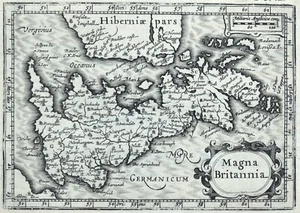
Antique Map GREAT BRITAIN, Magna Britannia, British Isles Original BERTIUS 1616

GBP 95.00
ApproximatelyUS $127.34
Condition:
“used”
- Buy It NowAntique Map GREAT BRITAIN, Magna Britannia, British Isles Original BERTIUS 1616
Oops! Looks like we're having trouble connecting to our server.
Refresh your browser window to try again.
Shipping:
GBP 22.00 (approx US $29.49) Royal Mail International Tracked.
Located in: Shrewsbury, United Kingdom
Delivery:
Estimated between Wed, Oct 15 and Mon, Oct 27 to 94104
Returns:
30 days returns. Buyer pays for return shipping. If you use an eBay shipping label, it will be deducted from your refund amount.
Payments:
Earn up to 5x points when you use your eBay Mastercard®. Learn moreabout earning points with eBay Mastercard
Shop with confidence
Seller assumes all responsibility for this listing.
eBay item number:177063895610
Item specifics
- Seller Notes
- “used”
- Antique
- Yes
- Date Range
- 1600-1699
- Type
- Political Map
- Format
- Atlas Map
- Printing Technique
- Copper Plate
- Year
- 1616
- Era
- 1600s
- Cartographer/Publisher
- Petrus Bertius
- Original/Reproduction
- Antique Original
- Country/Region
- England, Ireland, Scotland, United Kingdom, Wales
- Country/Region of Manufacture
- United Kingdom
Item description from the seller

Popular categories from this store
Seller feedback (19,059)
- e***l (491)- Feedback left by buyer.Past 6 monthsVerified purchaseVery nice map in good condition as described. Dispatched quickly and very securely packaged. Prices seem fair when compared to many others about the web. Highly recommended!Antique Map ENGLAND, Saxon Heptarchy SAXTON & HOLE, Camden Original 1637 (#177044832868)
- l***s (7090)- Feedback left by buyer.Past 6 monthsVerified purchaseLovely item, as described, immaculately packed and swiftly delivered - recommended seller 👍
- g***a (4275)- Feedback left by buyer.Past 6 monthsVerified purchaseGoods exactly as described, good communications – recommended sellerSUSSEX, JAMES WYLD Chichester, Brighton, Petworth Folding antique map 1865 (#176819350288)
More to explore :
- Isle of Wight Antique Original Antique Europe Maps & Atlases,
- British Columbia Antique Original Antique North America Atlas Maps,
- British Columbia Antique Original Antique North America Maps & Atlases,
- Antique European Maps & Atlases Isle of Wight,
- British Columbia Canada Antique Original Antique North American Maps & Atlases,
- Antique Original Antique Anthropomorphic Maps,
- Antique Original Political Map Antique Wall Maps,
- Antique Original Railroad Map Antique Folding Maps,
- Antique Original River Map Antique Folding Maps,
- Antique Original Physical Map Antique Sheet Maps
Popular categories from this store
Seller feedback (19,059)
- e***l (491)- Feedback left by buyer.Past 6 monthsVerified purchaseVery nice map in good condition as described. Dispatched quickly and very securely packaged. Prices seem fair when compared to many others about the web. Highly recommended!Antique Map ENGLAND, Saxon Heptarchy SAXTON & HOLE, Camden Original 1637 (#177044832868)
- l***s (7090)- Feedback left by buyer.Past 6 monthsVerified purchaseLovely item, as described, immaculately packed and swiftly delivered - recommended seller 👍
- g***a (4275)- Feedback left by buyer.Past 6 monthsVerified purchaseGoods exactly as described, good communications – recommended sellerSUSSEX, JAMES WYLD Chichester, Brighton, Petworth Folding antique map 1865 (#176819350288)